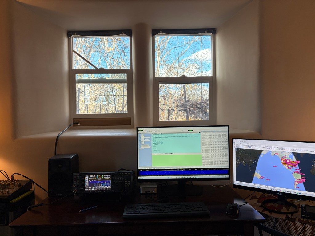
Welcome to my radio shack! My operating position has moved from Topanga, California to Nambé, New Mexico. My main HF radio is an Elecraft K4D loading up a multi-band doublet that is resonate on 80m. It is up about 40 feet in the cottonwood trees around the 100 year old adobe casita. For the digital modes I run Digital Master 780 and WSJT-X on a Geekom A6 mini computer running Windows 11.
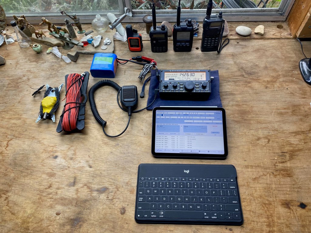
The SOTA station incorporates an Elecraft KX2 with a Bioenno 3AH external battery. My main SOTA antenna is a home brew 20 AWG zip cord doublet that is resonate on 40m. I also carry a PackTenna end-fed random wire antenna for quick deployment in tough conditions. For 2m and 70cm I use a Kenwood TH-F6a and a roll-up Slim Jim. Recently I’ve added a Yaesu FT5DR and APRS capability. The antennas are supported with a Goture 20′ carbon fiber fishing pole, a Jackite 30′ and a Jackite 20′ fiberglass masts. Also pictured is the first radio I ever owned after I got my license in 2002 — an ICOM IC-T7H. I used this radio exclusively on my first few activations
I gave up pencil and paper logging in favor of an iPad and external keyboard. It’s a bit more awkward for me to use in the field, but, man, it is so much easier when I get home to upload.
Lastly I use a Garmin InReach Mini for safety and posting spots when the mobile phone and APRS fail. Plus KG6MZR likes to see where I am when I am wandering about in the hinterlands.
Latest Posts

Willow Springs Butte
Looking south across the eponymous raceway to the hazy San Gabriel Mountains. Whitedog is visible below. 22 MARCH 2026 W6/ND-328 Elevation: 3,297′ Route: Cross country Hike Distance: .8 miles round trip Elevation Gain: 500′ Navigation: A slight twist* Steepness: Steep Vehicle: Passenger car Road: Good dirt road Cell Coverage: Excellent Verizon Hike basics This entire…

Santa Ynez Peak x2
Here’s the 2m SSB station amid all the other communications infrastructure on Santa Ynez Peak. 14 MARCH 2026 W6/CC-036 Elevation: 4,298′ Route: Drive-up Hike Distance: n/a Elevation Gain: n/a Navigation: easy Steepness: n/a Vehicle: Passenger car* Road: Mostly paved. 1/2 mile dirt Cell Coverage: Excellent Verizon *The dirt section is rough but nothing an average…

Summit 3,784′ “Nellie’s Mountain”
Looking west to some of my favorite summits in Ventura County: Santa Paula Peak, Hines Peak and Cobblestone Mt. 8 MARCH 2026 W6/CT-169 Elevation: 3,784′ Route: Equestrian trails Hike Distance: 2 miles round trip Elevation Gain: 400′ Navigation: Easy Steepness: Moderate* Vehicle: Passenger car Road: Paved road Cell Coverage: Excellent Verizon *Short steep section easily…

La Mesita
Venerable SOTA Goat Fred KT5X showing the new guy the ropes. La Mesita behind us. 16 FEBRUARY 2026 W5N/SS-039 Elevation: 7,024′ Route: Cross country Hike Distance: 1.6 miles round trip Elevation Gain: 400′ Navigation: Tricky Steepness: Steep gaining the mesa Vehicle: Passenger car Road: Good dirt road* Cell Coverage: Excellent Verizon * When dry! Ever…
Something went wrong. Please refresh the page and/or try again.
