
The tall skinny rock on the left is called The Bong (aka 2001) by rock climbers.
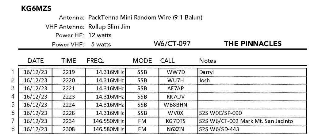
15 DECEMBER 2023 W6/CT-097

| Elevation: | 5,738′ |
| Route: | Trail |
| Hike Distance: | 3.7 miles round trip |
| Elevation Gain: | 875′ |
| Navigation: | Easy to lose the trail over rocks |
| Steepness: | Steep |
| Vehicle: | Passenger car |
| Road: | Paved road |
| Cell Coverage: | Good (Verizon) |
My last trip up to The Pinnacles was on May 5th, 1995. It snowed lightly that day and there was an earthquake the next day in Yucca Valley. This turns out to be a very nice hike to a very interesting summit. The trail is steep in places and can be tough to follow where it dodges the boulders strewn across the route. The trail is threaded through these areas and while most roads lead to Rome, some are easier than others. A few venture off into easy third class climbing.
Here is our descent route that, as usual, is a better way to the summit.
This time my brother Mark and I had a chamber-of-commerce day for our hike. Cool, clear and calm. We got a late start due to the long drive from Topanga Canyon, but still made it to the summit in time to have some fun with the radio and fly Chester the Drone. Here is a short video that includes a 360º panorama from 100m above the summit:
I gave this summit three stars because I found it it an interesting and surprisingly enjoyable hike. It was a long day door-to-door from home, so it might be better as a weekend hike with Mount Marie Louise and others.


Leave a comment