
Summit 4,054′ is a fine looking summit at the end of a steep hike.
15 APRIL 2023 W6/CT-156

| Elevation: | 4,054′ |
| Route: | Cross country and steep training trail |
| Hike Distance: | 4 miles round trip |
| Elevation Gain: | 2,000′ including 200′ on the return |
| Navigation: | A bit tricky to start, then easy |
| Steepness: | Steep |
| Vehicle: | Passenger car |
| Road: | Paved |
| Cell Coverage: | Excellent (Verizon), APRS Excellent |
I love this hike and I highly recommend it, but it is not a hike for everybody. At a little over two miles to the summit it is very steep. In fact, it appears that this hike is a training route for fire crews out of the Conservation Camp at the junction of Soledad Canyon and Maher Canyon just east of the trailhead. They call it “No Fear.”

I started the hike right at sunrise and mistakenly went up the hillside to the left of the little ravine where I parked Whitedog the Tacoma. It is actually better to climb up the short waterfall at the start of the ravine and head up to the saddle where it joins the “No Fear” route.
Here is my track up CT-156. I’ve posted this so you an see how long it took me. Normally I do 1 mile in 30 minutes or less. As you can see this hike 1 mile took me 72 minutes to ascend.
My descent is a better track to follow as a route up. Here is my track down CT-156
I suggest getting an early start if you plan on doing this hike on a warm day. The hike up will be cooler and the rattlesnake danger is less. You can mostly see where you are putting your feet, but, even so, I was glad to have my trekking poles for balance and to fend off any potential snake strikes on the much warmer descent.
It was nice and cool as I rapidly climbed the steep slopes covered in bright yellow Tree Poppies (Dendromecon rigida). The golden state flower, the California Poppy gets all the superbloom buzz in the media, but other wild flowers adorned this hike.

I was serenaded by the plaintive, single note cry of the Mountain Quail (Oreortyx pictus) as I hiked upward. It is a familiar sound to mountaineers in California and evokes a lazy nostalgia for me of dreamy afternoons in the clean, high air.
I also heard the strange, hollow sound of a Sooty Grouse (Dendragapus fuliginosus) calling.
One thing that really appeals to me about the summits on the backside of the San Gabriel Mountains is how little-travelled they are. I didn’t see another hiker the entire day. All the “big name” peaks on the crest would be packed on such a beautiful Saturday as this.
It took me two hours and twenty minutes to reach the summit. While I make frequent stops to catch my breath, I don’t usually sit down. I follow the old hiker’s maxim that this expends more energy that it is worth. I usually start to move slowly in a rest step after a minute or two.
Cassie (KG6MZR) and I were fortunate enough to catch Kevin (W6KCO) on this summit when he did it last winter. We were on Grass Mountain at the time so this was a really sweet complete made even better when Kevin was my first caller from his home in Canyon Country. Thank you Kevin.
Kevin had left a very well-made register on the summit and the only signatures in the little book were all SOTA activators!
It was somewhat breezy on the way up, but I managed to get Chester the Drone up in the air for a short video of the summit:
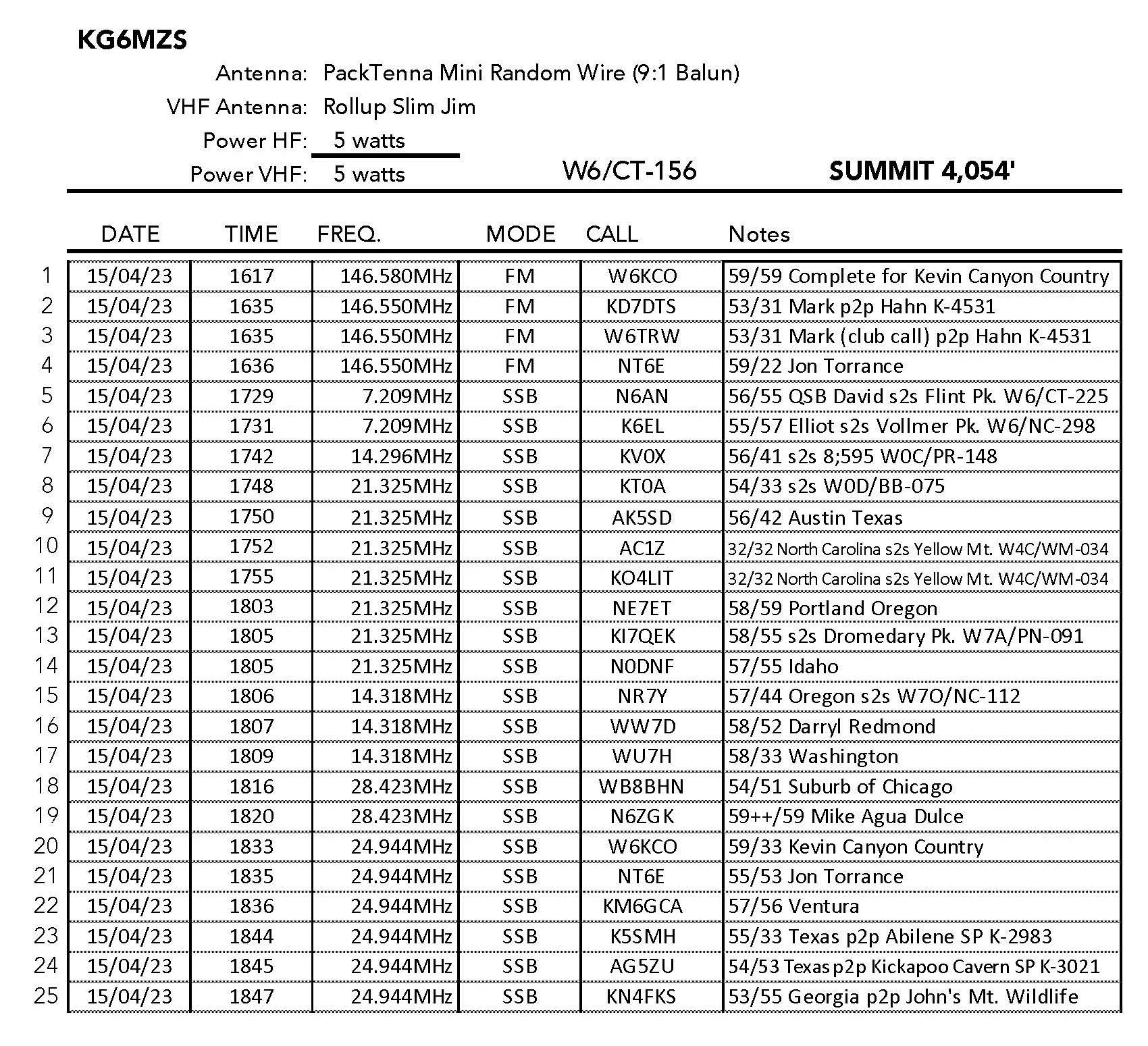
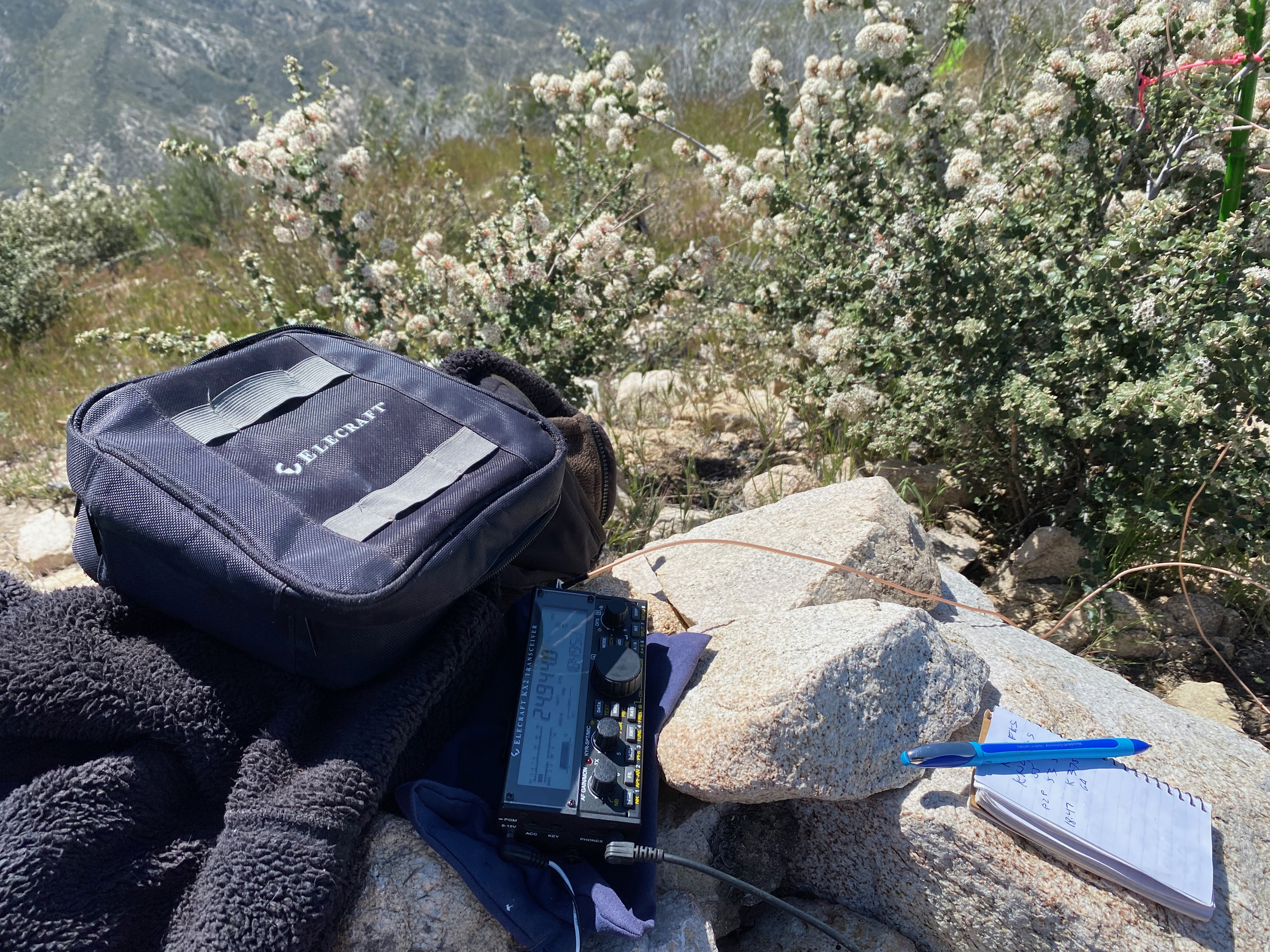
I had great fun making 25 contacts including 8 summit-to-summit contacts and 4 park-to-park contacts. This summit is in the Angeles National Forest and in the San Gabriel Mountains National Monument.
About noon the nice morning breeze died and the insects became noticeable. Small biting gnats attacked my elbows and it was time to pack up and hike down. It was pretty warm at this point and I consumed all of my litre and a half of water. Bring lots of water!


Leave a comment