
On the Edison road to the summit.
26 NOVEMBER 2022 W6/CT-144

| Elevation: | 4,460′ |
| Route: | Short cross country |
| Hike Distance: | .6 miles round trip |
| Elevation Gain: | 250′ |
| Navigation: | Easy |
| Steepness: | gentle |
| Vehicle: | SUV High clearance recommended |
| Road: | Edison dirt road |
| Cell Coverage: | Good (Verizon), APRS Excellent |
This activation didn’t exactly go smoothy but ended up being surprisingly enjoyable. In preparing for this one I noticed that the formidable Mountain Goat Dan NA6MG has done this one no less than 6 times! That’s a lot even for Dan so I suspected that this was a good one.
The only thing that wasn’t clear to me was access. KB1KXL had mentioned a locked gate so I pulled up the private property map on my Gaia GPS app:

I saw that the BPL road had access points that seemed to be all within the San Gabriel Mountains National Monument so I drove off the Angeles Forest Highway to Aliso Canyon Road. I found an access point that had an open gate with a sign that warned that the road was patrolled and that damaging the powerlines was a crime with a $1,000 fine but no road closed, private property, no tresspassing or keep out signs. I suspect the road to the west was probably a little shorter and less steep, but I didn’t check it out for a gate.
Upon getting to the point of the BPL road that was the trailhead. I discovered that I had left my SOTA pack in the driveway at home. Again. New rule: car must be packed the night before any before-dawn SOTA excursions. I tend to leave stuff in the hour before my bucket of strong coffee has kicked in.
Once again, however, I did have my trusty Yaesu FT-5DR and, strangely enough, Chester the Drone. I knew that making contacts on this side of the San Gabriel Mountains with 5 watts and a glorified rubber duck antenna would be iffy, but, what the hay, I’d come this far.
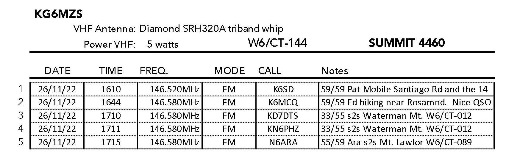
The “hike” is short – just a third of a mile and up 250 feet or so, but the summit was surprisingly nice with a good antenna support – If I had an antenna to support 😉 I started calling CQ … and calling… …and calling… Just one contact would count as an activation if not give me the points, so I kept calling. Even with a spot on SOTAWatch3 I was having no luck on 146.580, so I jumped over to the national calling frequency 146.520 in hopes of catching a total rando.
Eureka! Pat K6SD was motoring on Soledad Canyon Road and came back to me full quieting. We chatted for a bit and I was happy to at least get the activation. I flew the drone and took some photos waiting a bit because it was still pretty early.
Then I caught KD7DTS and KN6PHZ hiking on their way up Mount Waterman. Hoo hoo! only one more needed for the points. Then I caught Ed K6MCQ hiking near his home out near Rosamond. We had a long, very pleasant ragchew. Activation points secured! I hung out waiting for those guys to reach the summit of Waterman when I heard Ara N6ARA work them summit-to-summit. Score – I worked all three for more s2s points then I had managed in a month or more.
I originally had planned to activate 4,300 W6/CT-262 as well but my battery was running low on the HT so I just marked the jump-off point from the BPL road (red waypoint on the map above) for next time.
The bonus epilogue to the day was that DTS and PHZ went on to activate East Twin Peak and I worked them once I got back home for my second complete of the day. Lemonade from lemons!


Leave a comment