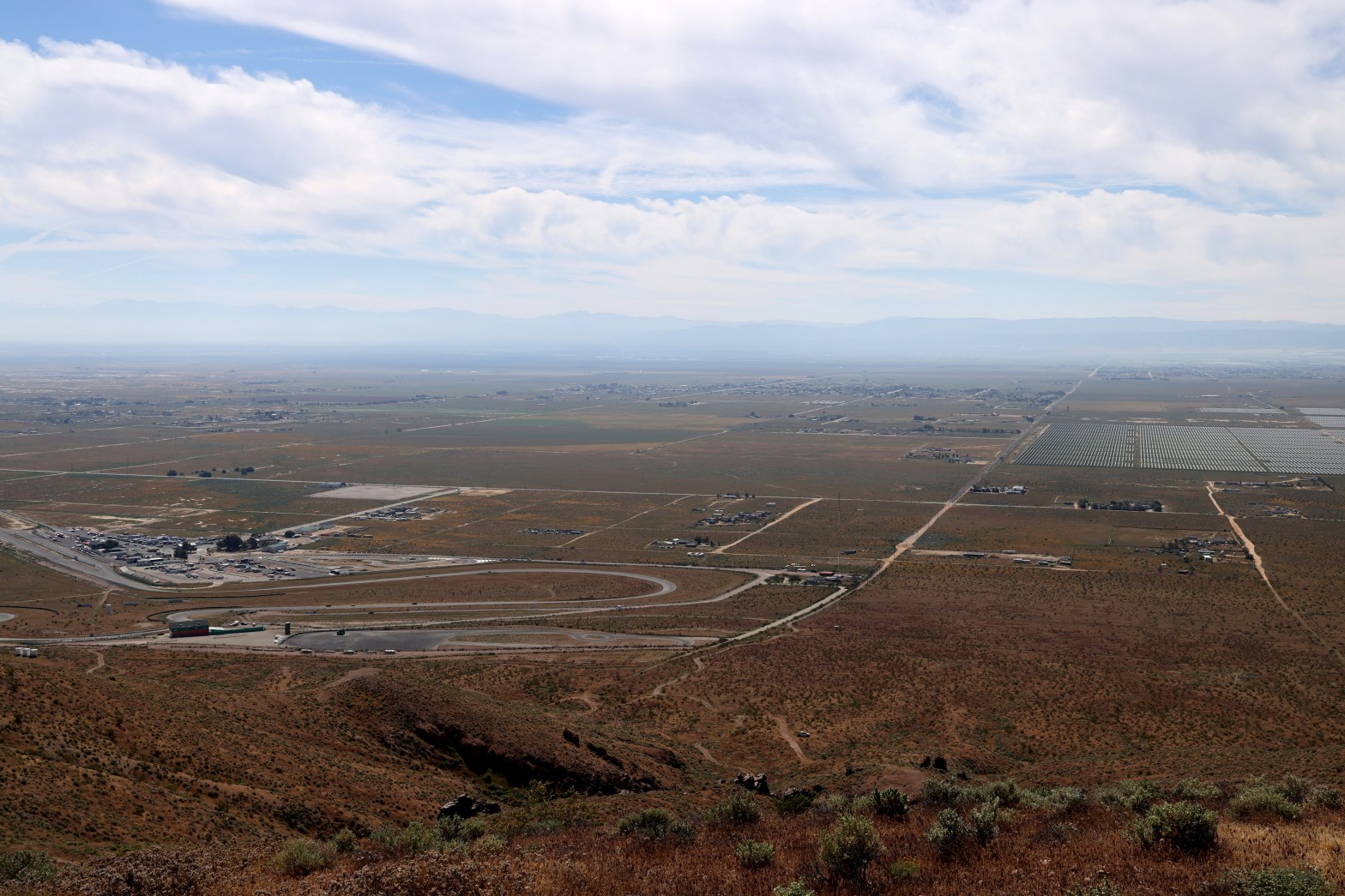
Looking south across the eponymous raceway to the hazy San Gabriel Mountains. Whitedog is visible below.
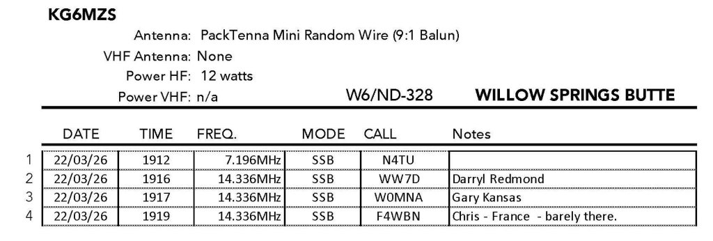
22 MARCH 2026 W6/ND-328
No stars – This is a one-off summit. I am unlikely to return. Not recommended..
Elevation:
3,297′
Route:
Cross country
Hike Distance:
.8 miles round trip
Elevation Gain:
500′
Navigation:
A slight twist*
Steepness:
Steep
Vehicle:
Passenger car
Road:
Good dirt road
Cell Coverage:
Excellent Verizon
Hike basics
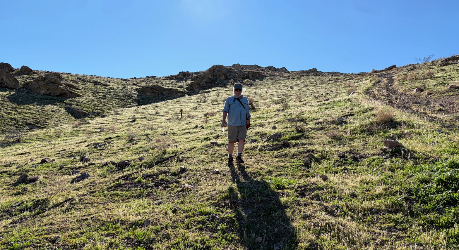
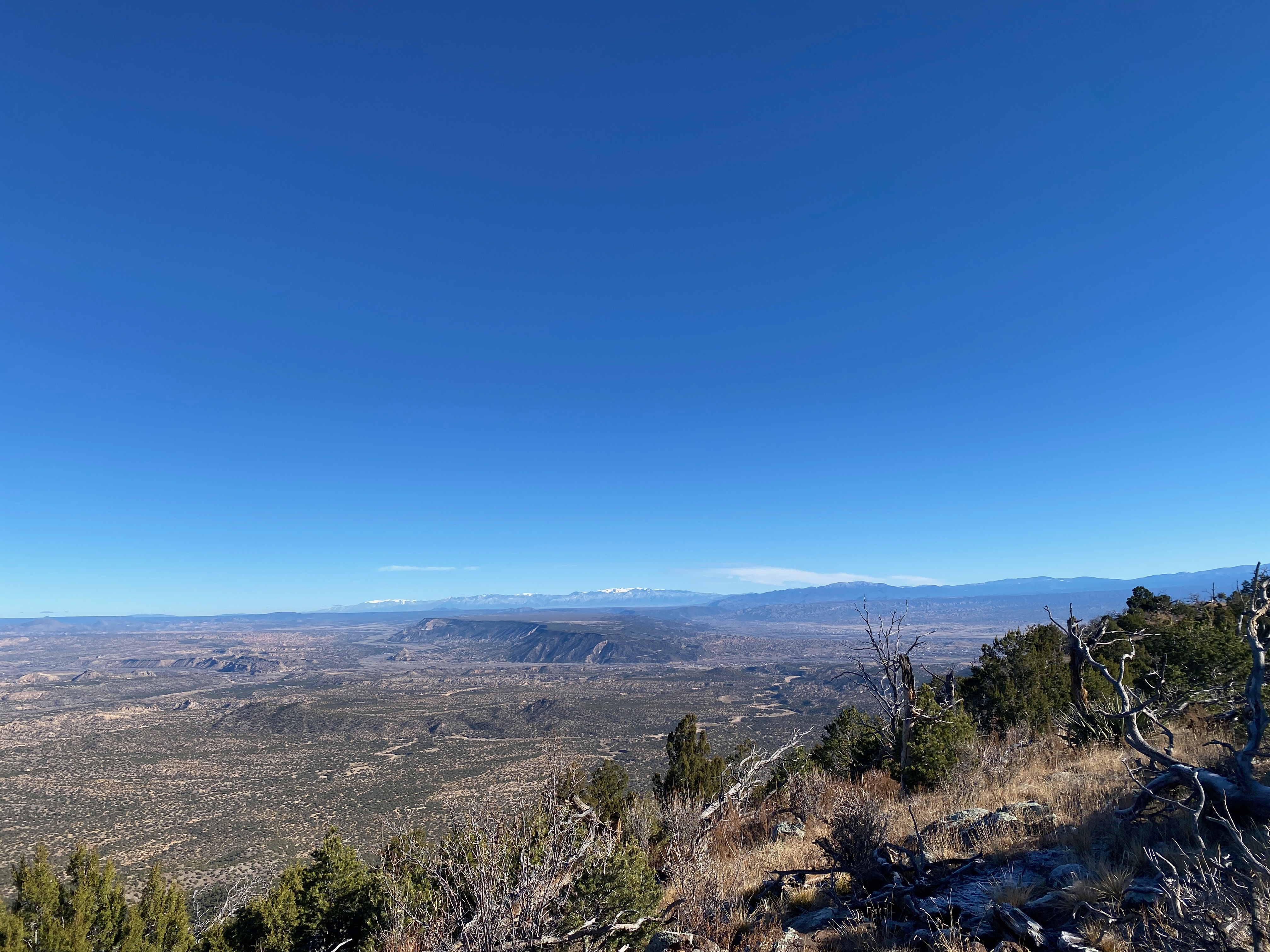
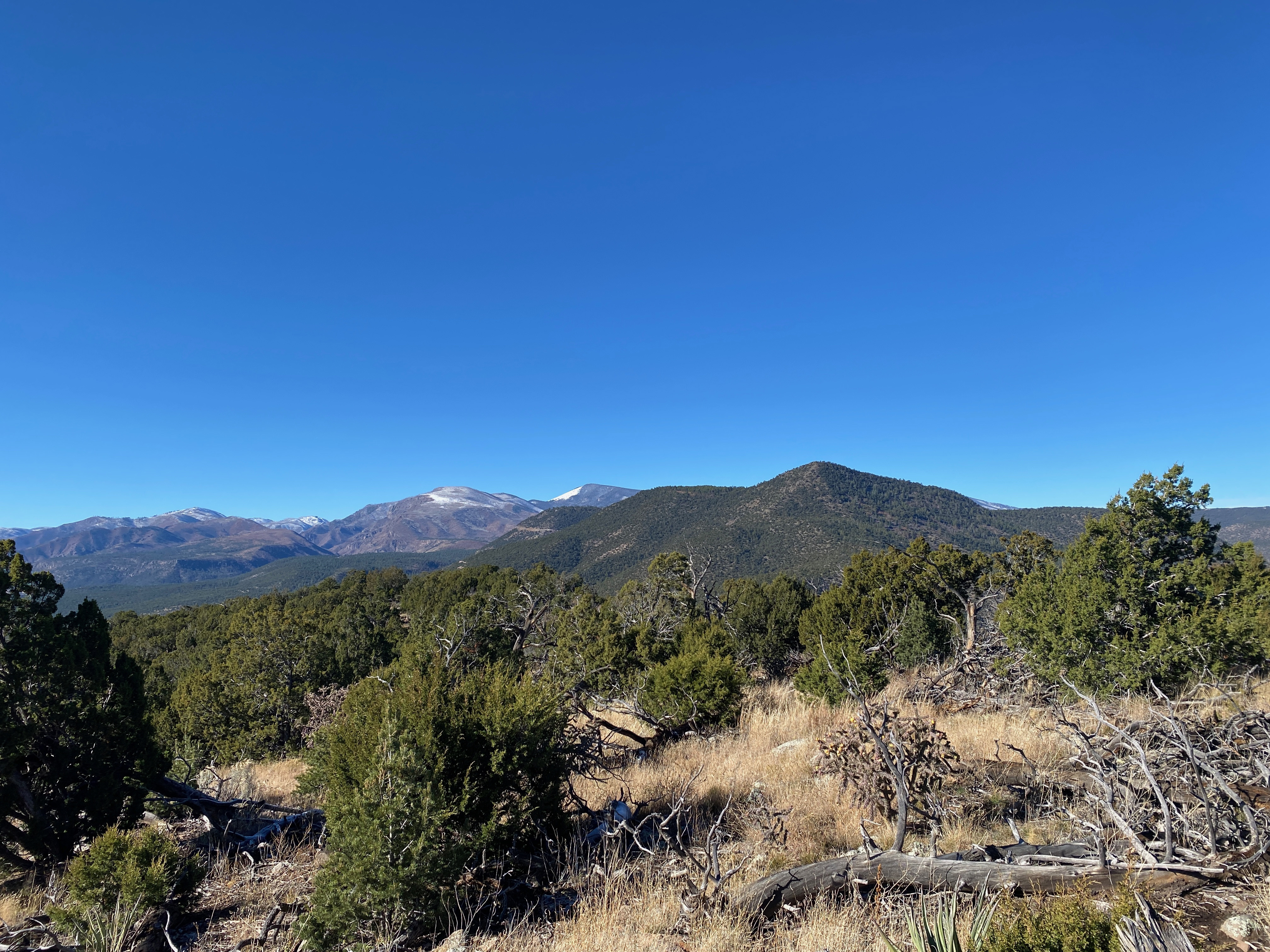
This entire activation was a punt. Plan C. I started my morning before dawn in Woodland Hills and headed for Tehachapi Pass looking to do a pair of summits out of Walker Basin. In all my years of exploring Southern Califonia, this was a corner of the Golden State I had somehow managed to overlook. This historic, out-of-the-way place was really showing off her charms as I wound up the narrow loop only to discover that the north and south access roads were gated, locked and posted with “Private Property, No Trespassing” signs.
Disappointed, I pointed Whitedog back toward the Antelope Valley and activated my “plan C” summit; Willow Springs Butte. My brother Mark and I had activated nearby Rosamond Hills on a recent Sunday and were dismayed by the plethora of careless target shooters. We repeatedly heard not only the report of the firearms, but the whooshing of projectiles whistling through the air.
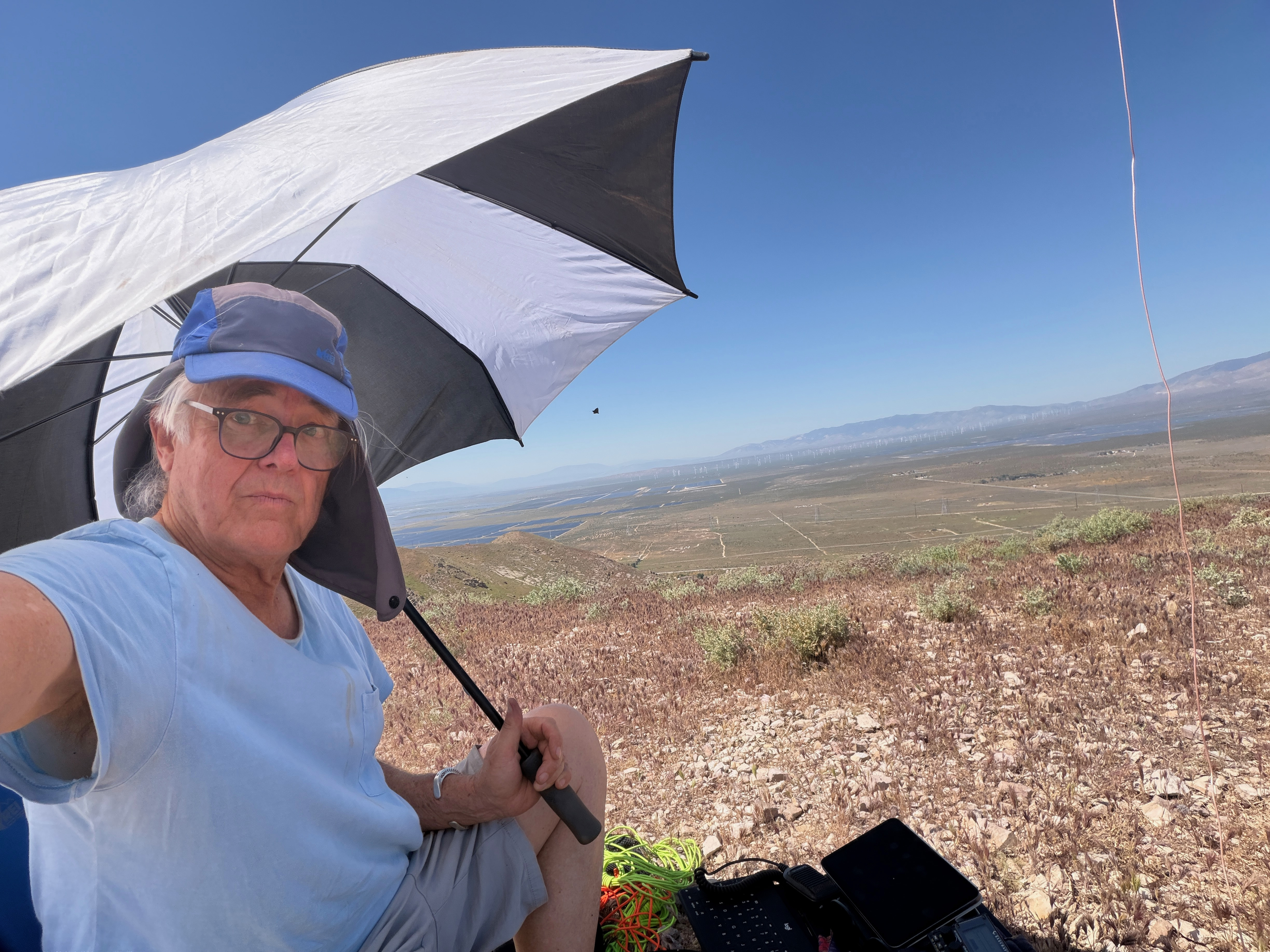
Also it had been unseasonably hot for the vernal equinox and I knew it could be pretty toasty. I drove to the end of Truman Road and turned up toward the summit and 4-wheeled up a way. The cross country route was fairly steep and it was quite warm, as I had expected.
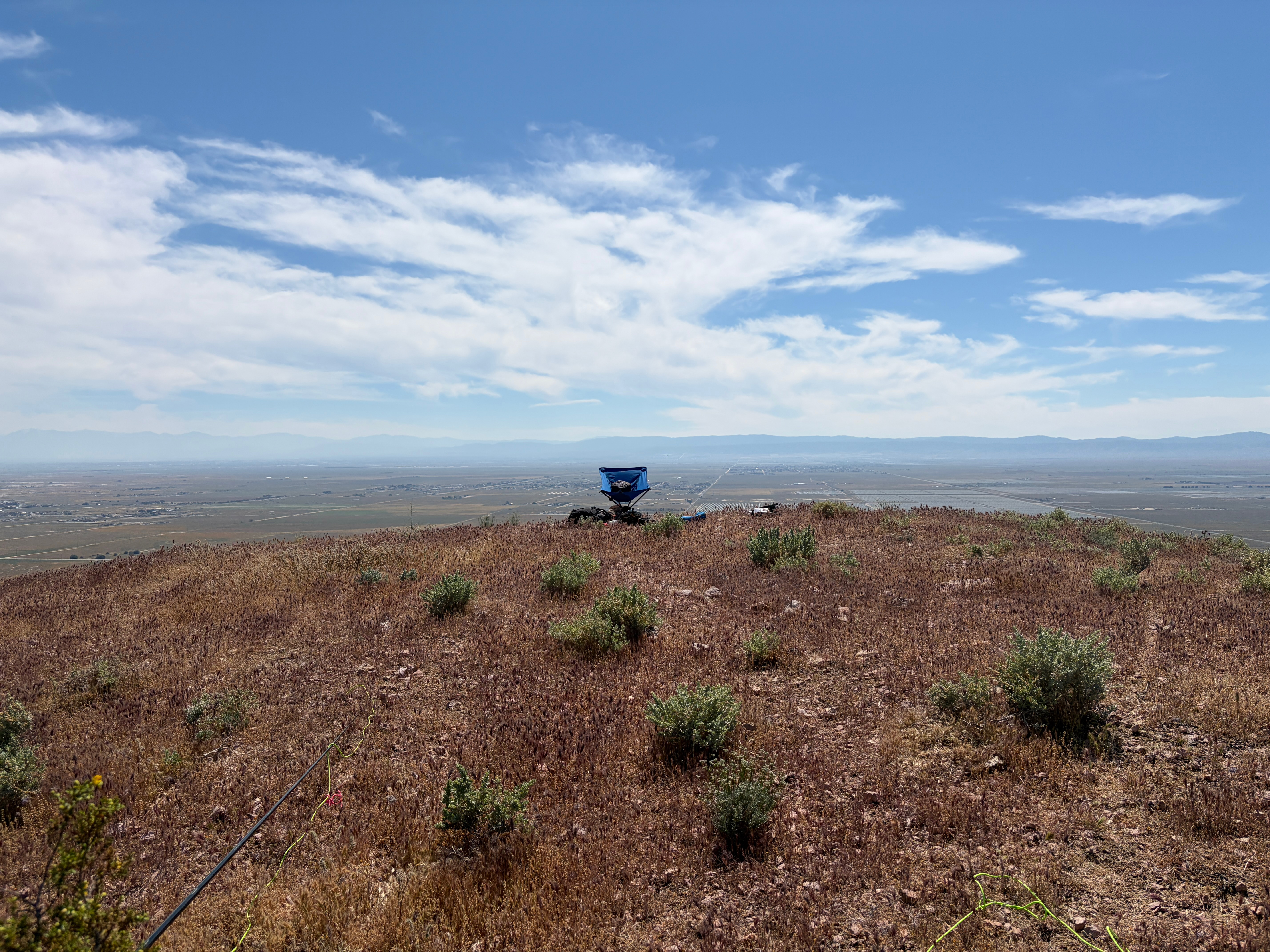
Once I gained the ridge, I mistakenly turned to the west and ascended the high point there. Interestingly SOTA Goat reported that I was in the activation zone on that summit when the dip between that point and what was certainly the actual summit was more than 82 feet. Once I returned to the dip, SOTA Goat did report that I was not in the AZ.
The summit only has a few low bushes to support masts. Fortunately I had an umbrella for shade as the gear certainly would have overheated without it.
The constant roar of Willow Springs Raceway and the ubiquitous Antelope Valley gunfire make this summit a one-off for me. Fortunately the shooters were more distant than they were on Rosamond Hills. I would suggest doing this one very early on a weekday. It’s probably pretty nice then.
Radio conditions were horrible and I didn’t feel like hanging out.
The silver lining was that on the way back the floor of the Antelope Valley was carpeted in orange flowers. They weren’t California Poppies – I don’t know what species they were.
Thankfully some shade.Looking south across the bare summit to the San Gabriel Mountains.A visitor.Snow was still visible on Baldy and Baden-Powell through the smog. Click to enlarge.North to the Tehachapi Mountains.Northeast to Soledad Mountain and the former Silver Queen Mine (Now Gold Queen)
Here’s the 2m SSB station amid all the other communications infrastructure on Santa Ynez Peak.
14 MARCH 2026 W6/CC-036
One star – Nothing special but I’d do it again.
Elevation:
4,298′
Route:
Drive-up
Hike Distance:
n/a
Elevation Gain:
n/a
Navigation:
easy
Steepness:
n/a
Vehicle:
Passenger car*
Road:
Mostly paved. 1/2 mile dirt
Cell Coverage:
Excellent Verizon
*The dirt section is rough but nothing an average car can’t do.
I have been wanting to join in the 2026 SOTA Challenge fun with a 2 meter SSB activation for a while now, but patching together the suitable equipment proved to be a “challenge” in itself. Most of my radio gear is in our new temporary home in New Mexico. For this trip I brought my first-ever HF radio out of retirement: a Yaesu FT-100D. I’d never much used the VHF section of this little DC-to-light all-mode wonder, so this was something new for me. All I had to power the FT-100D was a hefty deep cycle marine battery and the only antenna that would suit was my old roof-top Comet CX-333.
This was obviously need to be a drive-up
In looking for drive-ups that might “see” a lot of Southern California’s robust 2m SSB community, Santa Ynez Peak seemed like it might work well. My only concerns were the RF saturated environment on such a massive “techno summit” and the somewhat precarious road conditions in the Santa Ynez Mountains as they had received a lot of rain this season.
Both concerns proved to be unfounded as the boulders and other detritus from the deluges had been cleared and the road was open. Furthermore, the venerable FT-100D’s front end did a decent job of rejecting adjacent signals. I only had a moment in a QSO with Darryl WW7D on 20m where a maelstrom of QRM made pulling Washington out a bit tricky.
The drive up was a joy with Santa Barbara County showing off her wondrous late winter, verdant beauty. The UCSB ROTC was running recruits to the summit apparently from Refugio State Beach. Yikes! I saw a few very exhausted young people with full packs.
I was thrilled to get my very first-ever 2m SSB contacts on a summit. Longest was K1CT in San Diego. Icing on this particular cake was a 2m sideband contact with David N6AN on “Mount Hodge” (formerly Flint Peak). This QSO entailed dodging some pretty large piles of dirt, namely Sandstone Peak, Cahuenga Peak, Simi Peak, Conejo Mt., Calabasas Peak, and the Verdugo Hills (see photo below.). … and no activation is ever complete without Jon NT6E in Torrance, on 2m sideband no less!
The not-insignificant pile of gear for this one.I’m guessing that David N6AN was out there between Calabasas Peak and Santa Paula Peak somwhere. Click to enlarge.
Santa Barbara’s Channel Island were out there in the haze of the day. Click any image to enlarge:
Santa Cruz IslandSanta Rosa IslandSan Miguel IslandSanta Ynez Valley with her characteristic marine layer.
Looking west to some of my favorite summits in Ventura County: Santa Paula Peak, Hines Peak and Cobblestone Mt.
8 MARCH 2026 W6/CT-169
One star – Nothing special but I’d do it again.
Elevation:
3,784′
Route:
Equestrian trails
Hike Distance:
2 miles round trip
Elevation Gain:
400′
Navigation:
Easy
Steepness:
Moderate*
Vehicle:
Passenger car
Road:
Paved road
Cell Coverage:
Excellent Verizon
*Short steep section easily avoidable.
Another activation that almost didn’t happen. Originally I was thinking about Zaca Peak up in Santa Barbara County, but I had the good sense to check the road conditions. It seems all of Figueroa Mountain was closed due to the rains earlier this year. It had been extremely windy the last couple of days in Los Angeles County and up Santa Barbara way it was forecast to be less so.
Then I thought about so-called “Nellie’s Mountain.” Usually if the wind is bad here in the flatland, it is much, much worse in the Escondito Canyon/Highway 14 corridor. But I was primed and ready to do an activation and I figured I could always blow it off (if you will forgive the expression) if the wind proved to be too much.
As it turned out the wind wasn’t too bad and there was a sheltered spot to set up behind a big chunk of basalt on the summit. This activation turned out to be quite enjoyable.
The hike up is pretty straightforward. I found a variety of equestrian trails the avoided the steeper OHV tracks. The high desert floor was carpeted with a multitude of minute and colorful flowers and green grass. This hike would probably get two stars from me if the noise from the Antelope Valley Freeway wasn’t ever-present.
As Dan NA6MG said previously park at the sign that says “6808 E.C.R” and head up that dirt road. The route goes across land that is part of the old Red Rover Mine land. It’s all private property but there are no fences or signs to indicate no trespassing.
Radio conditions were decent on 40m and 20m. A contest had 15m packed end-to-end, so I didn’t try and do battle with the big guns.
The station. Click to enlarge.Mount Gleason and Parker Mountain are prominent to the south. Click to enlarge.Plenty of room to set up.Interesting basalt outcrop. Click to enlarge.Don’t know what kind of flower this is. Click to enlarge.
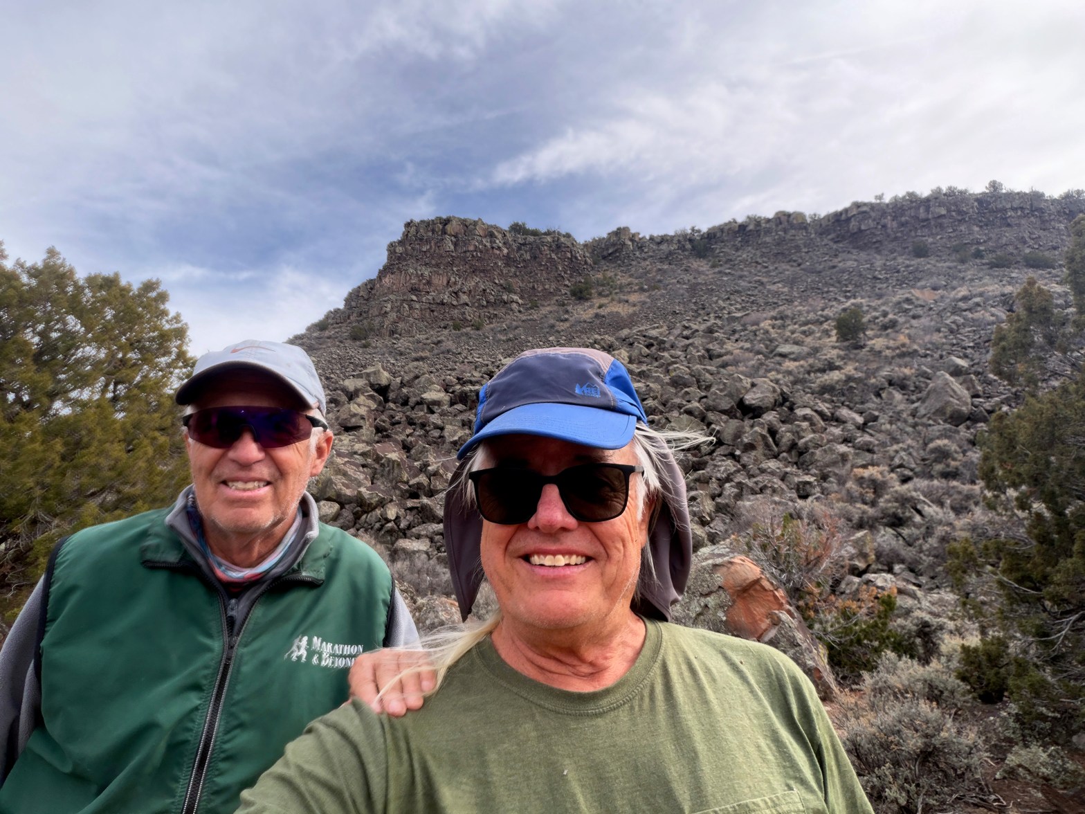
Venerable SOTA Goat Fred KT5X showing the new guy the ropes. La Mesita behind us.
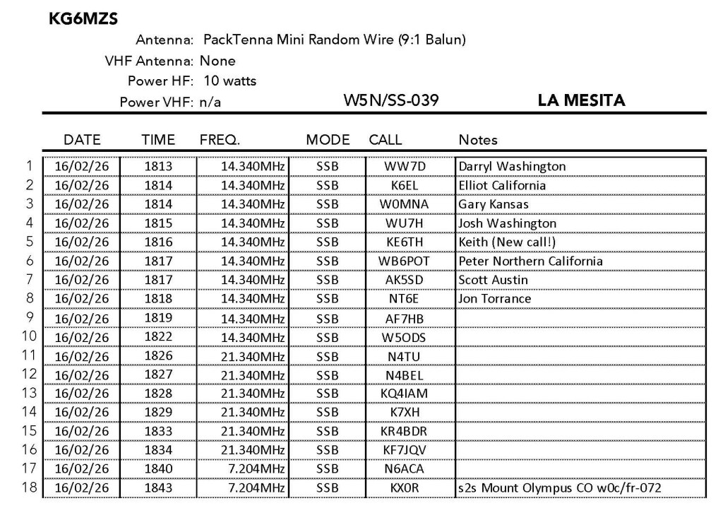
16 FEBRUARY 2026 W5N/SS-039
Two Stars – a nice summit. I’d do it again. Recommended.
Elevation:
7,024′
Route:
Cross country
Hike Distance:
1.6 miles round trip
Elevation Gain:
400′
Navigation:
Tricky
Steepness:
Steep gaining the mesa
Vehicle:
Passenger car
Road:
Good dirt road*
Cell Coverage:
Excellent Verizon
* When dry!
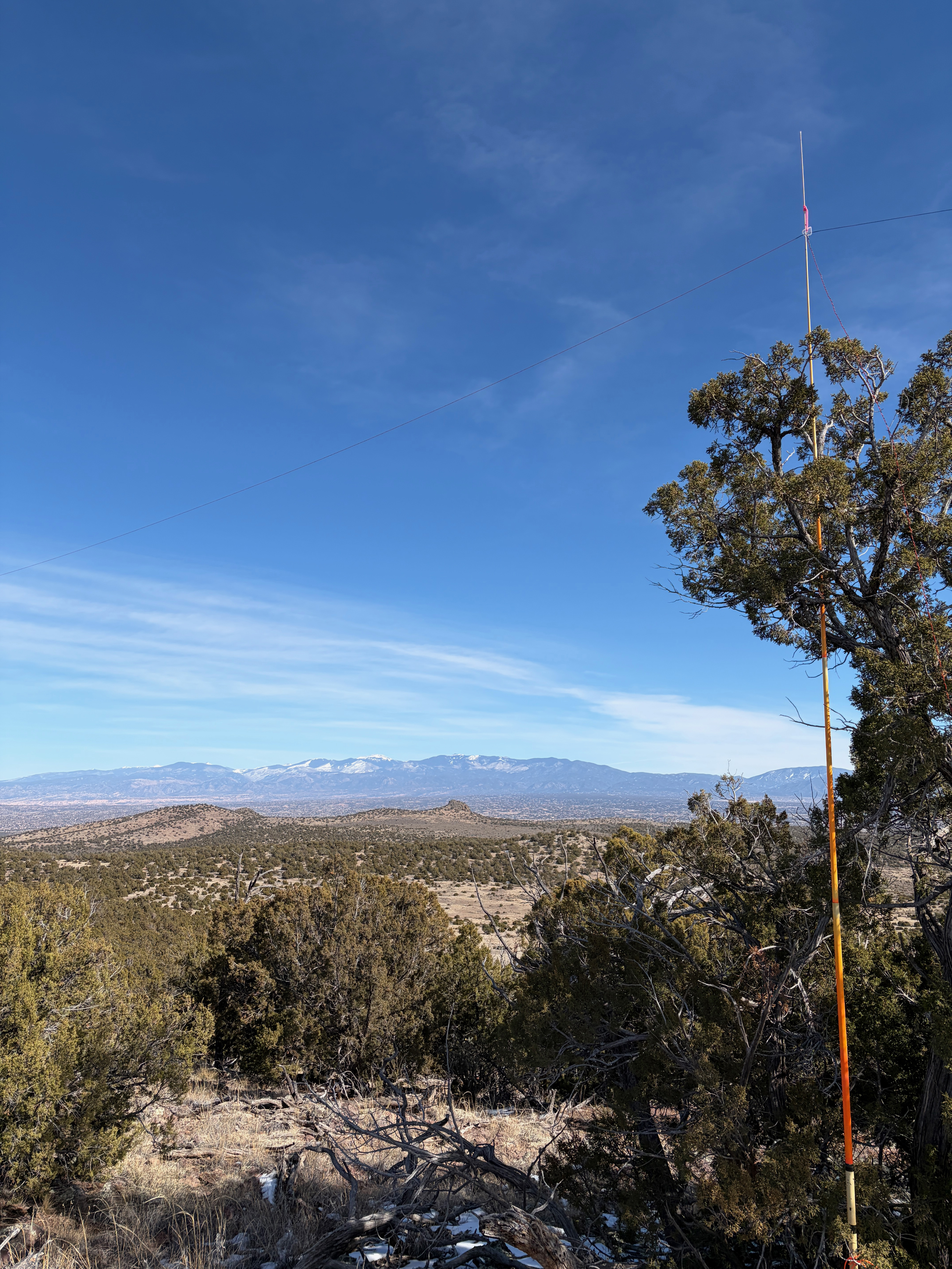
Ever since coming to New Mexico to activate SOTA summits I’ve been picking the brain of New Mexico’s SOTA guru Fred Maas via email. Fred normally activates during the week so to avoid weekend crowds and I am generally limited to weekends, early mornings and holidays by my work. We have tried to get together several times in the past few years to activate a summit and, finally, we managed to meet up in Pojoaque at 8:40 AM on President’s Day, 2026.
If you have never met Fred, he is a wealth of wide ranging knowledge from amateur radio to geology, history, native American lore and beyond. A great hiking companion.
We had a nice morning as we drove in Fred’s Xterra Off-Road up the length of the Española Valley and into the gates of the Taos Plateau at Velarde. I was the beneficiary of Fred’s experience of how not to gain the tableland of La Mesita by following a ducked route that largely avoided the basalt blocks and cliffs that form the apron around the mesa.
As one might gather from this summit’s name, the activation zone is HUGE! One regret I have is that Fred opted for a nice spot near the edge of the mesa to activate, while I opted to continue on a considerable distance to the actual summit. This meant that I did not get a chance to see Fred in action with his amazing micro mini CW station.
Conditions were okay and I managed contacts with many of the usual suspects
Here’s a little video I made from the trip. Turn up the sound and enjoy:
Two Stars – a nice summit. I’d do it again. Recommended.
Elevation:
7,306′
Route:
Cross country
Hike Distance:
1 mile round trip
Elevation Gain:
325′
Navigation:
Easy
Steepness:
Mild
Vehicle:
High clearance, all terrain tires recommended
Road:
Dirt road
Cell Coverage:
Excellent Verizon
Hike basics
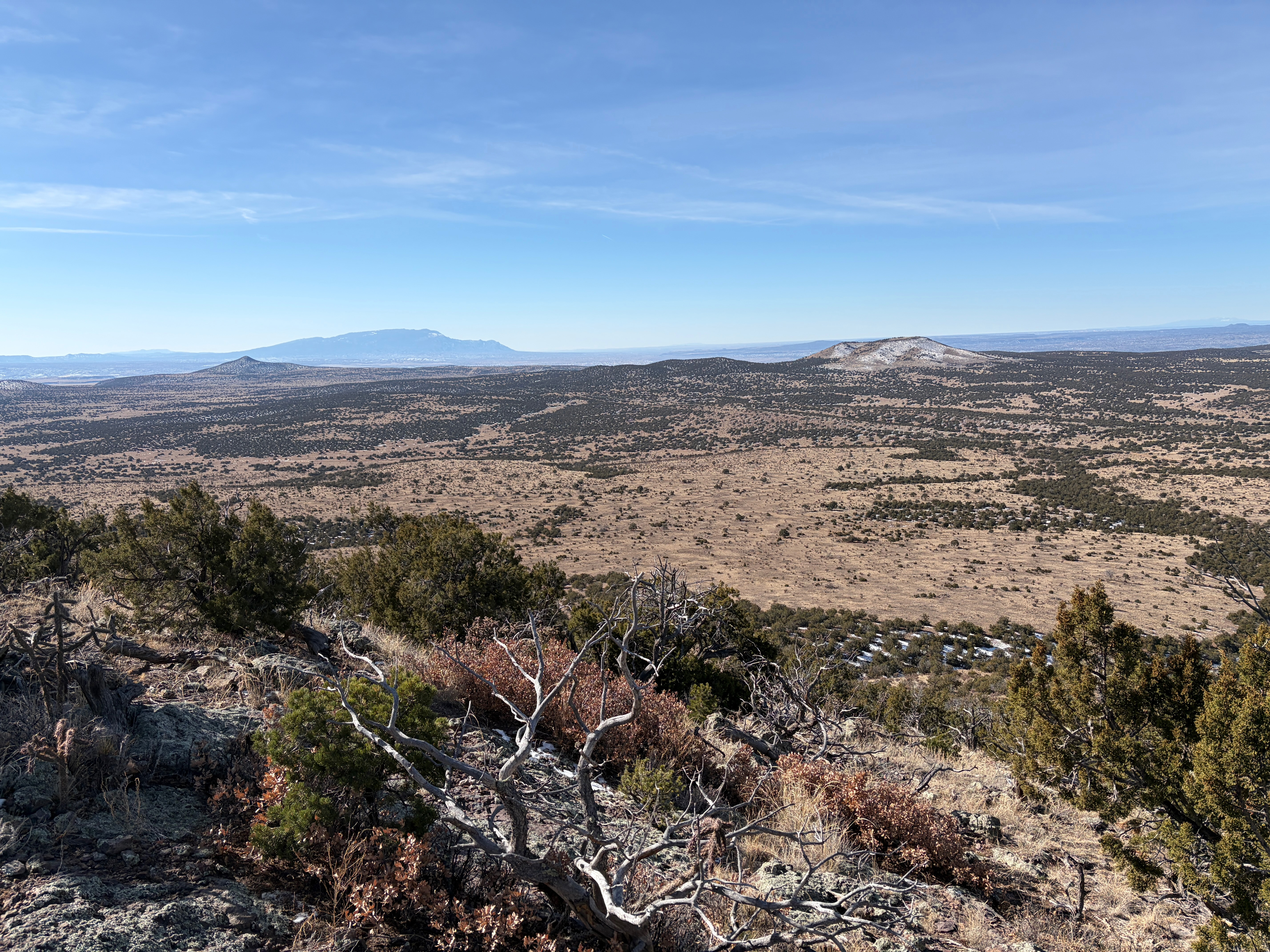
After doing Tetilla in the morning, I felt like exploring the Caja further, so I pointed Whitedog north on Forest Service Road 24. I took this good dirt road to the corrals at the Twelve Hundred Well junction and took Forest Service Road 21E to the west. Note that these roads are not well marked so a good Forest Service map is helpful.
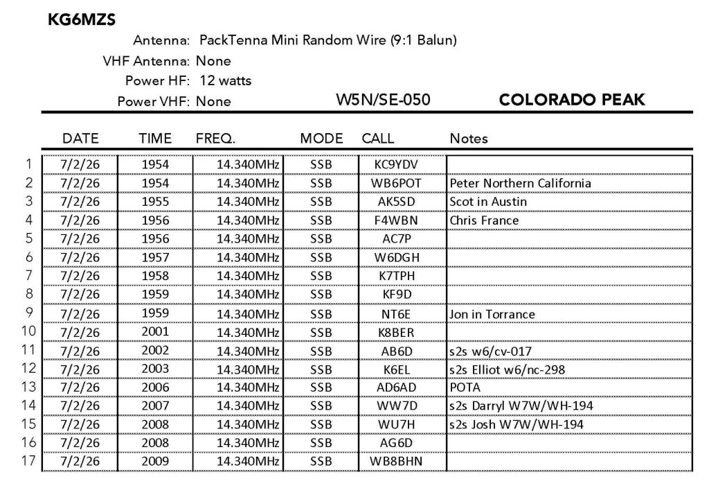
From here I was able to drive up a very faint track to the base of the hill leading to Colorado Peak. The hike is short and it goes through a burn area from a 2020 fire sparked by lightning. The clear skies I had over Tetilla Peak earlier clouded up considerably. I could see verga in the upper atmosphere and I began to wonder if we weren’t going to get an unforecasted shower. This could complicate the drive out on the adobe roads.
The activation area is huge and a surviving juniper provides shade and shelter on the otherwise open ridge. Cow pies are everywhere and I had to rake manure to clear the spot I chose.
Radio conditions were again good although I only worked a decent pileup on 20m
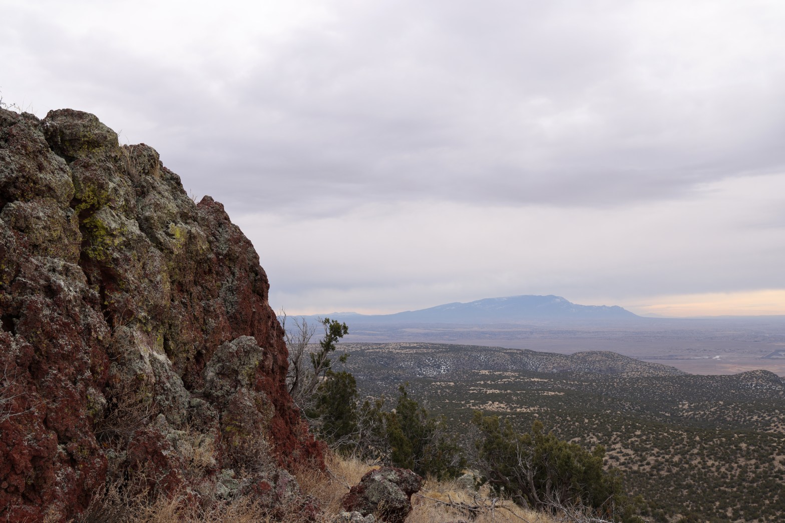
The StationLooking north over the burn area, past Picuris Peak, to Wheeler Peak up by Taos.Chicoma Mountain, Los Alamos and Clara Peak to the northwestLooking east to Santa Fe Baldy and the Truchas across the Caja del Rio Plateau.Looking south to the Sandia Crest.
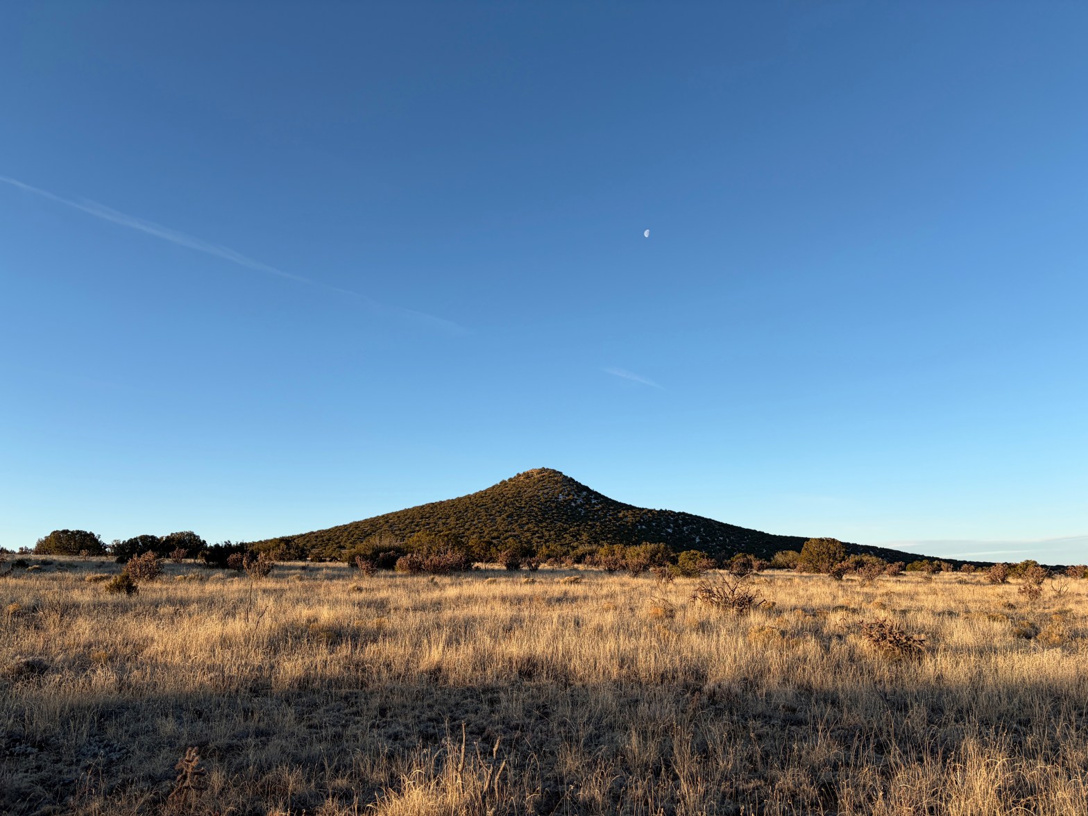
Tetilla Mountain at dawn looking very much like its namesake
7 FEBRUARY 2026 W5N/SE-044
Two Stars – a nice summit. I’d do it again. Recommended.
Elevation:
7,201′
Route:
Cross country
Hike Distance:
1.75 miles round trip*
Elevation Gain:
525′
Navigation:
Easy
Steepness:
Moderate
Vehicle:
High clearance, all terrain tires recommended
Road:
Dirt road
Cell Coverage:
Excellent Verizon
Your mileage will vary depending on where you park.
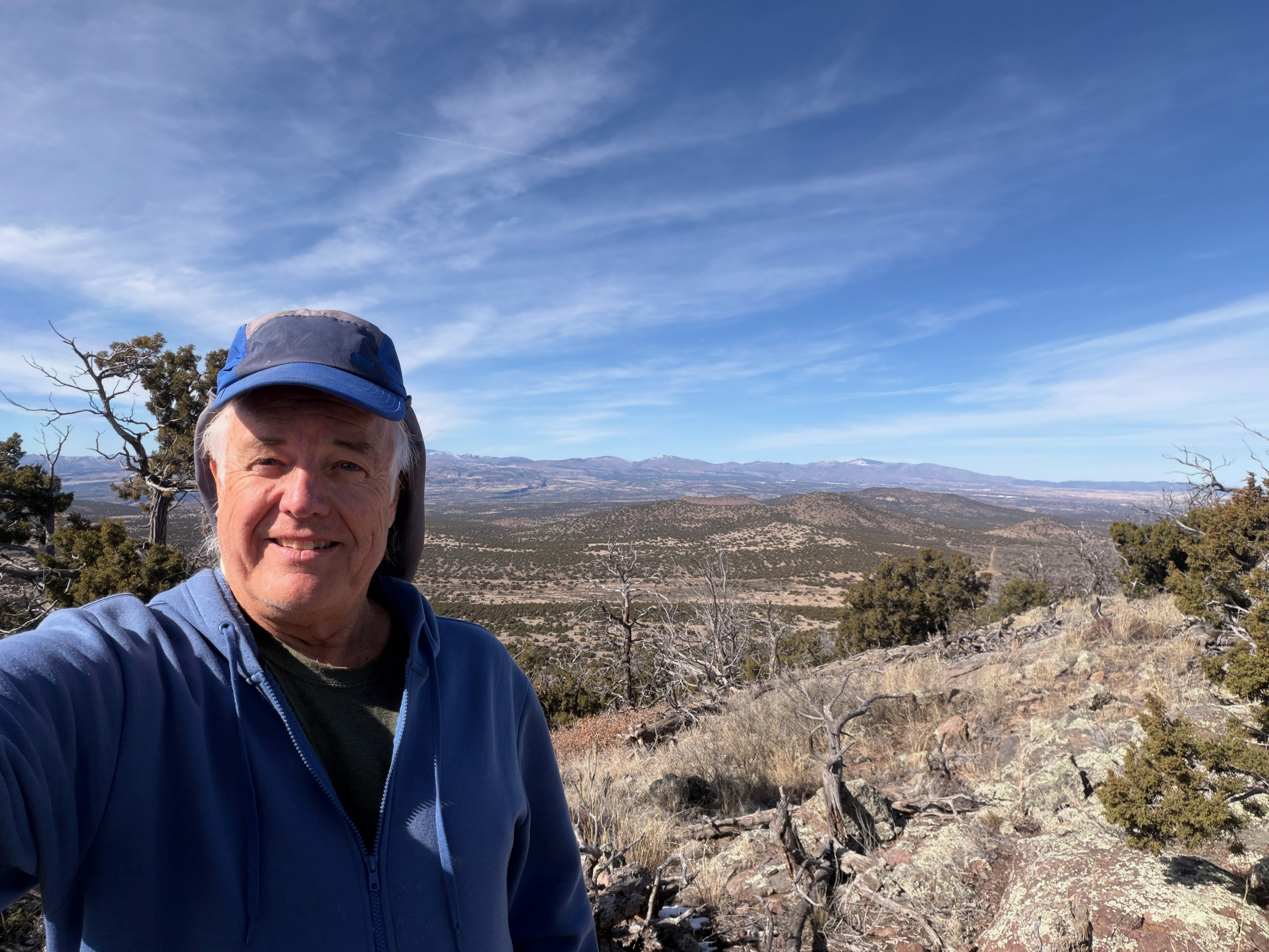
Our plans changed at the last minute and suddenly my pre-super bowl Saturday opened up. I did what I love to do: left the casita in the dark before dawn on an adventure to a new place!
My new mountain romance is with the Caja del Rio Plateau, or simply The Caja. I set my sights on a new approach – from the south end. Fred KT5X says “there are no ‘roads’ to Tetilla Peak” and this is true. There are some tracks that get you close, but keep in mind Fred’s warning about the sharp volcanic rock in the area.
Also take note of Fred’s warning about footwear. Besides the sharp volcanic rock there are some vicious cacti low to the ground. I was wearing some La Sportiva Nucleo high top boots and a spine from one of these little devils managed to puncture both boot and sock.
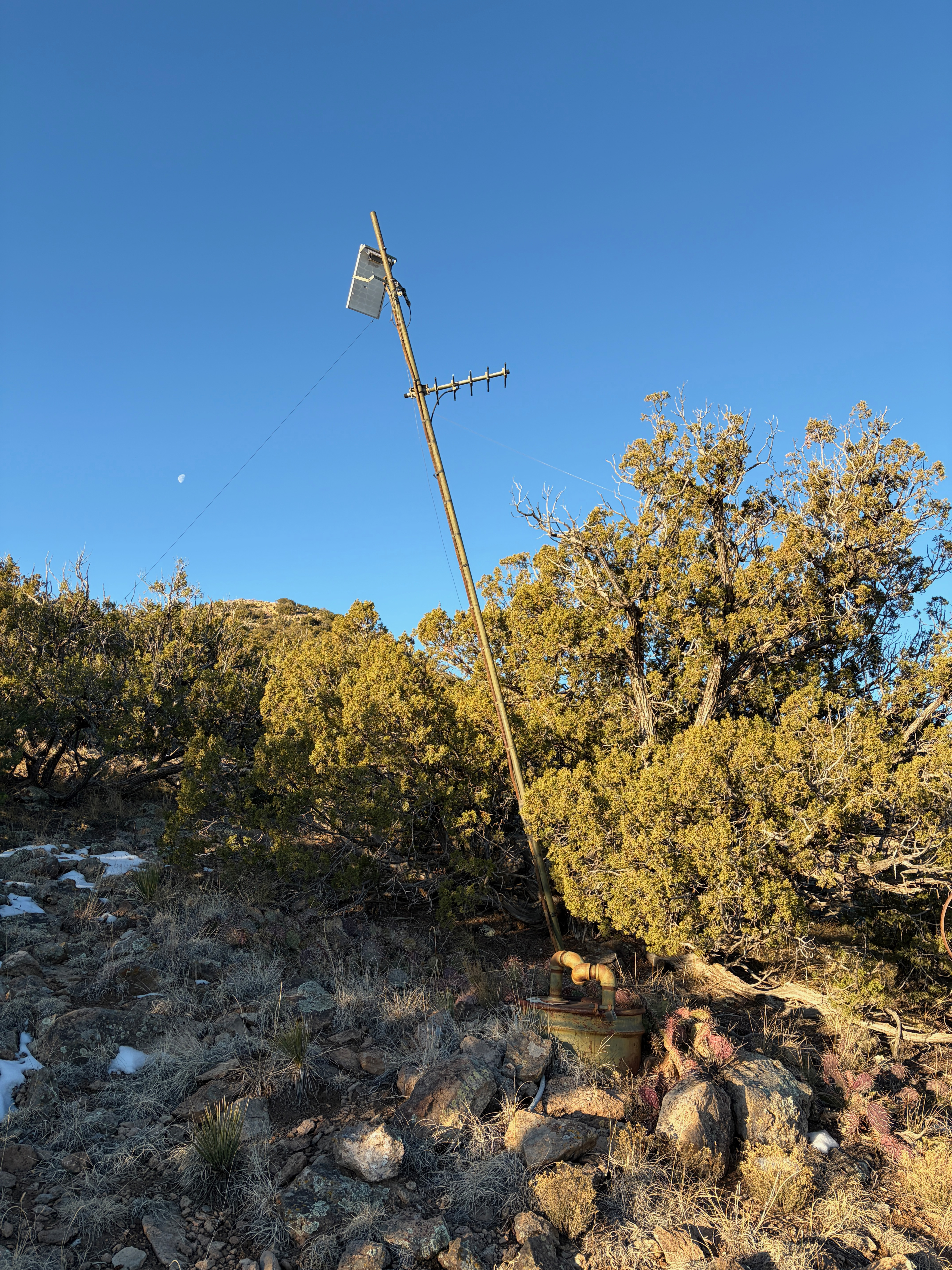
On the way up I passed this curious installment:
Click to enlarge
It appears to be some kind of groundwater or well monitor, but that’s just a guess.
There was a register on the summit – something you don’t find too often in New Mexico. It only went back to 2024 but I saw Fred KT5X’s sign in.
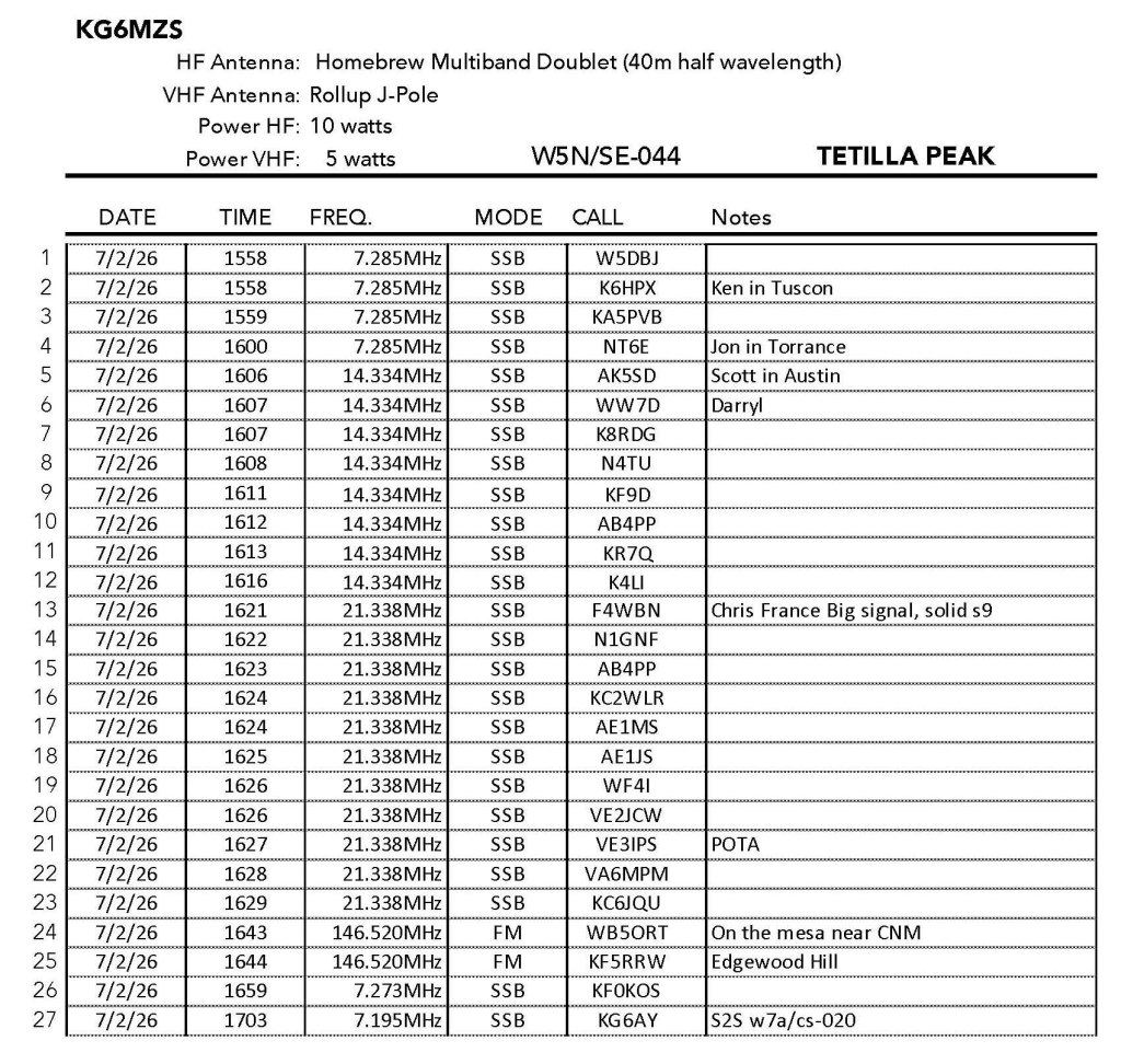
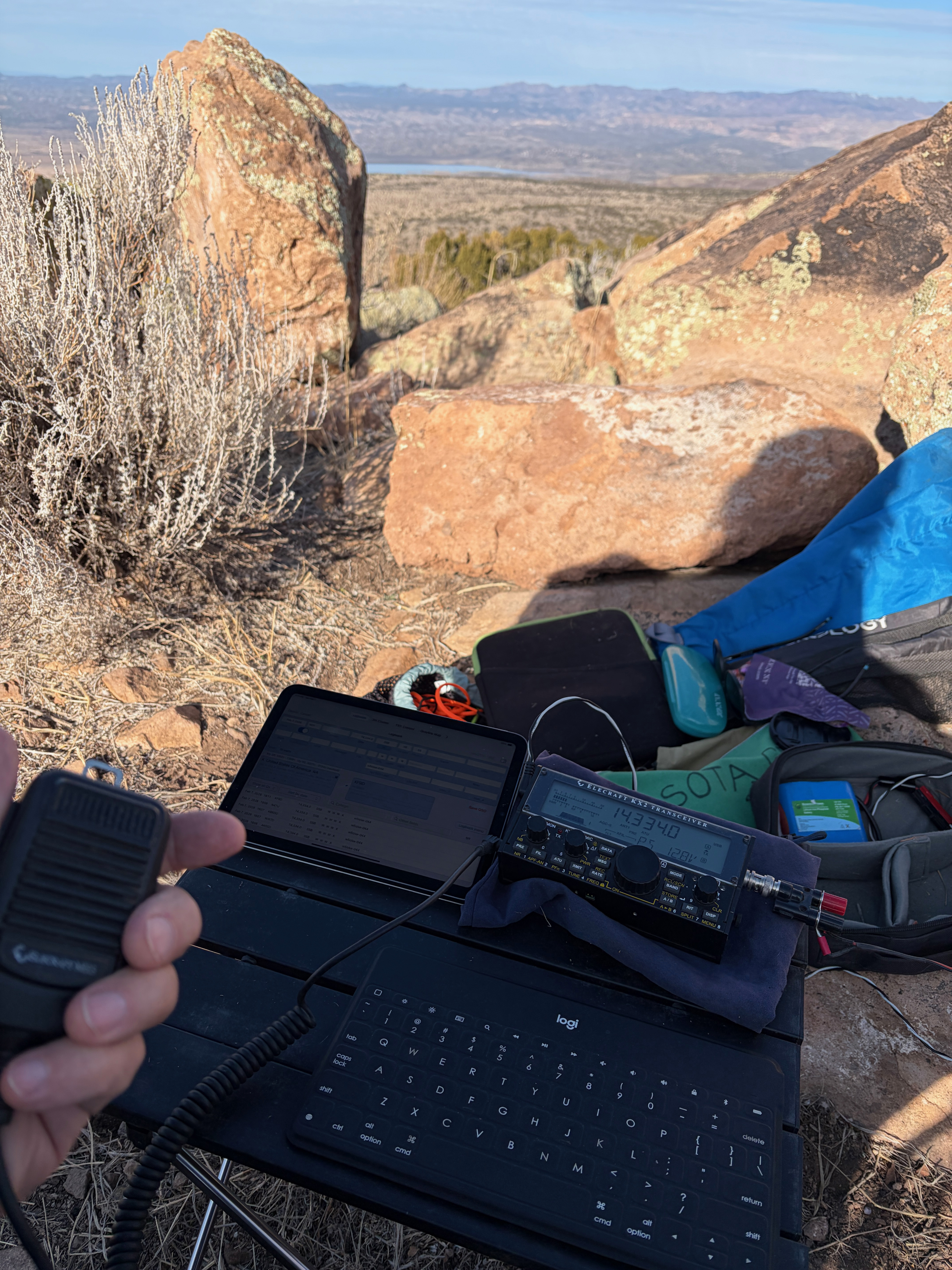
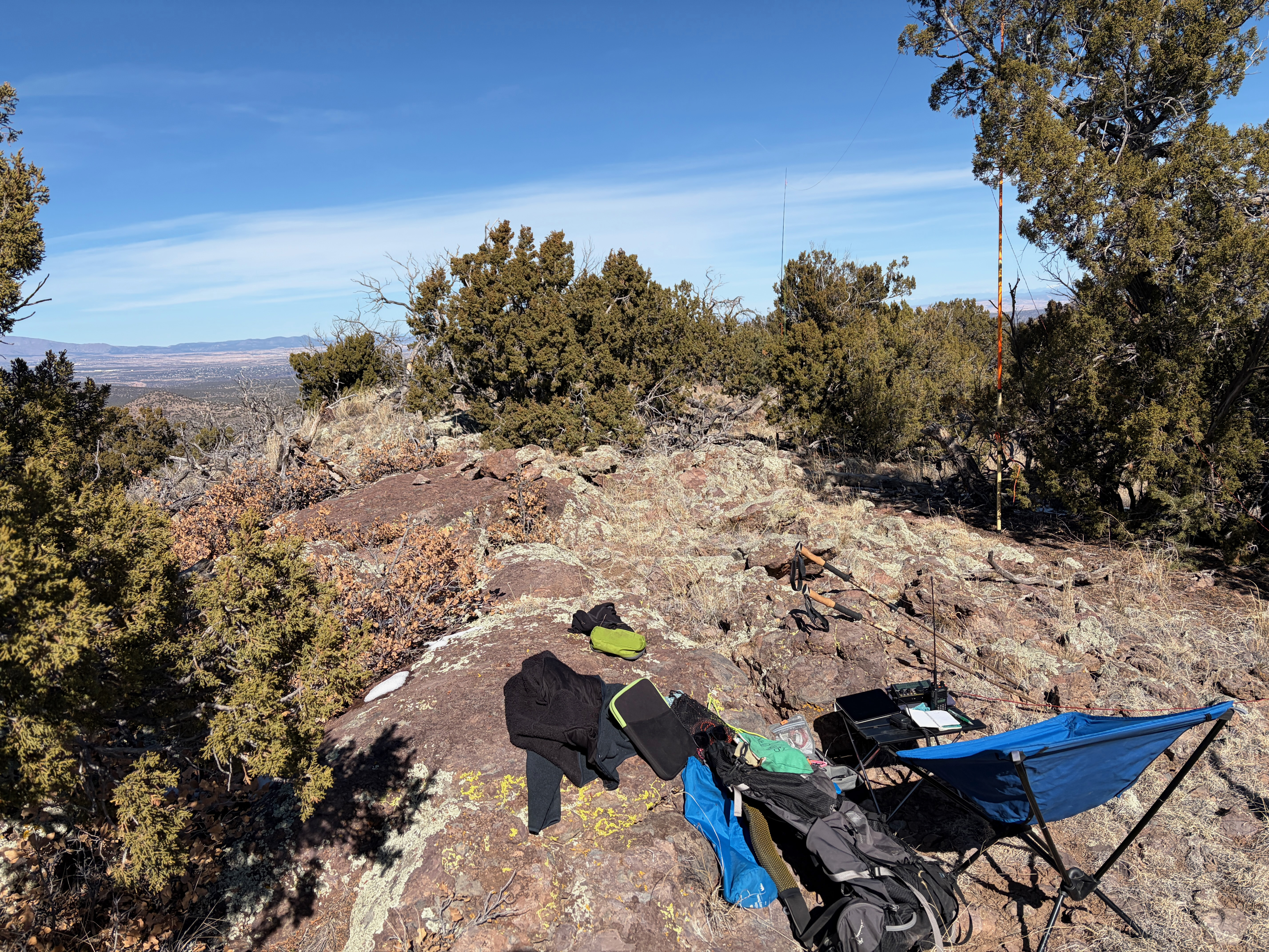
The hiking is otherwise open and easy. The summit commands a lovely view and it was easy to set up three masts for support of my doublet. Radio conditions were very good with Christian in France booming in at an honest-to-God s9. I had pileups on 20m and 15m happily populated by all the usual suspects.
I wrapped it up and headed down to do Colorado Peak (W5N/SE-050) next.
The station with Cochiti Reservoir in the background.Cochiti Reservoir. Perhaps Bear Springs Mountain behind?Looking west towards Santa Fe and the Sangre de Christo.Looking south to the Sandia Crest and San Pedro Mountains.Looking northwest to Chicoma Mountain and next on the day’s list, Colorado Peak.The main mast and the north mast of the doublet. Note the rollup J-pole attached to the main mast.
An exciting drive, Whitedog waits in front of a northwest view of Parajito, Chicoma, Clara and Roman above Los Alamos.
1 FEBRUARY 2026 W5N/SE-037
Two Stars – a nice summit. I’d do it again. Recommended.
Elevation:
7,470”
Route:
Cross country
Hike Distance:
.5 miles round trip
Elevation Gain:
100′
Navigation:
Easy*
Steepness:
Gentle
Vehicle:
High clearance 4WD with all terrain tires**
Road:
Rocky
Cell Coverage:
Good Verizon
*Hike is easy, the drive is tricky. **Off road tires suggested.
Not being the most experienced off-highway driver (I don’t do off road), I approached this one with some trepidation. I was going out alone and I just don’t have the experience to try anything too difficult. The Caja del Rio Plateau is a maze of wood cutting tracks that have a lot of sharp lava, deep ruts and volcanic soil that can get really sticky when wet. There was some snow on the ground and a few muddy spots but I managed to get around them. Fred WT5X had warned me that the sharp lava can cut the sidewall of your average mud and snow tire and leave the unaware 4-wheeler woefully stranded. Fortunately Whitedog has BF Goodrich KO2s all-terrain tires which are adequate.
The route I took out was shorter, but it got a bit vague in places and I found a much more established route on the way back.
Here is the driving route on dirt that I found easier then the shorter route I drove in on.
There is a shorter route down the west side of the mountain but it crossed too many contour lines for me to attempt. More experienced drivers would probably have no trouble with it.
A sample of the road.
It was a gorgeous day up on the plateau. Cool and sunny with almost no wind. I had a nice activation even getting a summit-to-summit with Carol KE6SRN and Tom KE6SRO on Denk Mountain back in California. Carol, Tom and I activated Cerro Grande a few months back. I also had a nice, long armchair QSO with Eric KJ5GFK over in Los Alamos on 2 meters
Scarlett Hedgehog on the summit basalt.Looking east past my doublet’s center mast to Santa Fe Baldy and the Truchas Peaks.Looking south to the Titilla Peak, Sandia Crest in the distance and Colorado Peak Selfie looking northwest to Chicoma Mountain and Los AlamosThe station
My brother Mark descending what would’ve been a nice hike.
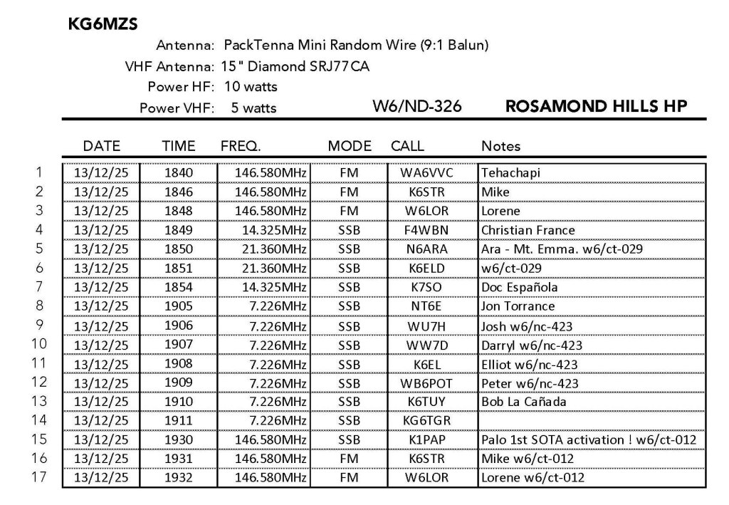
13 DECEMBER 2025 W6/ND-326
No stars – This is a one-off summit. I am unlikely to return. Not recommended..
Elevation:
3,330′
Route:
Cross country
Hike Distance:
1 mile round trip
Elevation Gain:
460′
Navigation:
Easy
Steepness:
Moderate
Vehicle:
Passenger car
Road:
Good dirt road
Cell Coverage:
Excellent Verizon
Hike basics
WARNING: This hike is in a very POPULAR TARGET SHOOTING AREA. Our experience was that the shooters were less than careful. One nearby group was firing so high in the air that we not only heard the report of the firearms but we could hear the bullets whistling through the air on the summit. I suspect midday Saturday is not a good time to try this summit. Perhaps very early in the morning and/or on a weekday would be better.
It’s really too bad because this is otherwise a really nice easy hike to an interesting geologic summit with a cool view.
As Hal N6JZT and Jeff AA6XA previously noted the drive to the trailhead is on the north side off an unnamed road. Turn west off the Mojave/Tropico Road at 34° 55′ 44.62″ N, 118° 12′ 44.64″ W. Then between 57 Street West and 60th Street West (34° 55′ 44.71″ N, 118° 14′ 12.01″ W) turn south and drive as far as you are comfortable on an increasingly steep dirt road.
The hike was short and enjoyable. Just follow the use trail that leads up and to the left over very interesting breccia clasts and other igneous conglomerates.
The summit has a series of igneous blocks the proved to be quite useful dodging the bullets. One party below set up and proceeded to fire in our direction. We yelled down but it only seemed like they were aiming at us after that as projectiles continued to whizz through the air.
Radios conditions were good and I was treated to a joint activation summit-to-summits from a whole herd of SOTA Mountain Goats: Josh WU6H, Darryl WW7D, Elliot K6EL and Peter WB6POT on Mount Davidson in San Francisco. First time activator Paolo K1PAP was over on Mount Waterman with Lorene W6LOR and Mike K6STR. I wish I could have stayed longer on this summit!
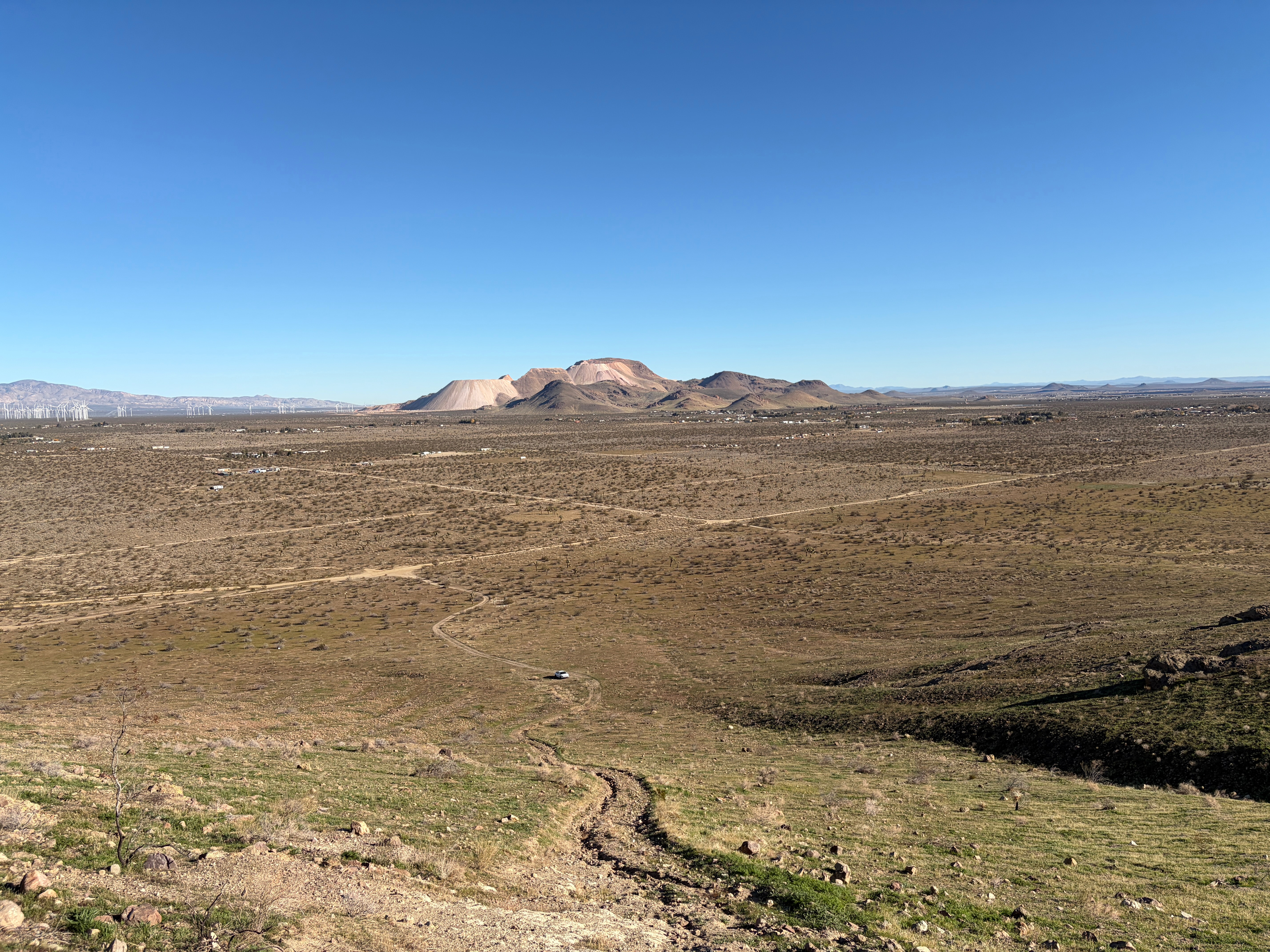
Golden Queen mine on Soledad Mountain behind my brother Mark in his rental car as far as we dared drive.Golden Queen Mine – I always mistakenly called it Silver Queen near Mojave up the approach road,Looking up at the summit. Didn’t get any pictures from the top due to the flying lead.
Tuff layers of volcanic ash laid down over a million years ago interspersed with basalt.
28 NOVEMBER 2025 W5N/SE-048
A Summits On The Air Classic!
Elevation:
6,549′
Route:
Nice trail
Hike Distance:
4.33 miles round trip
Elevation Gain:
1,000′
Navigation:
Easy
Steepness:
Steep gaining the mesa
Vehicle:
Passenger car
Road:
Good dirt road
Cell Coverage:
Excellent Verizon
Hike basics
Wonderful hike! As Fred KT5X states “This is an excellent hike for locals and visitors alike!” Bring your camera and be prepared for glorious vistas, interesting geology, flora, fauna and some fascinating history. My only caveat is that given the uphill sections are all southern exposures, this is one best done in cooler weather. Glittery frost and ice on the puddles marked my path as I left Whitedog by the Rio Grande with temps in the 20’s.
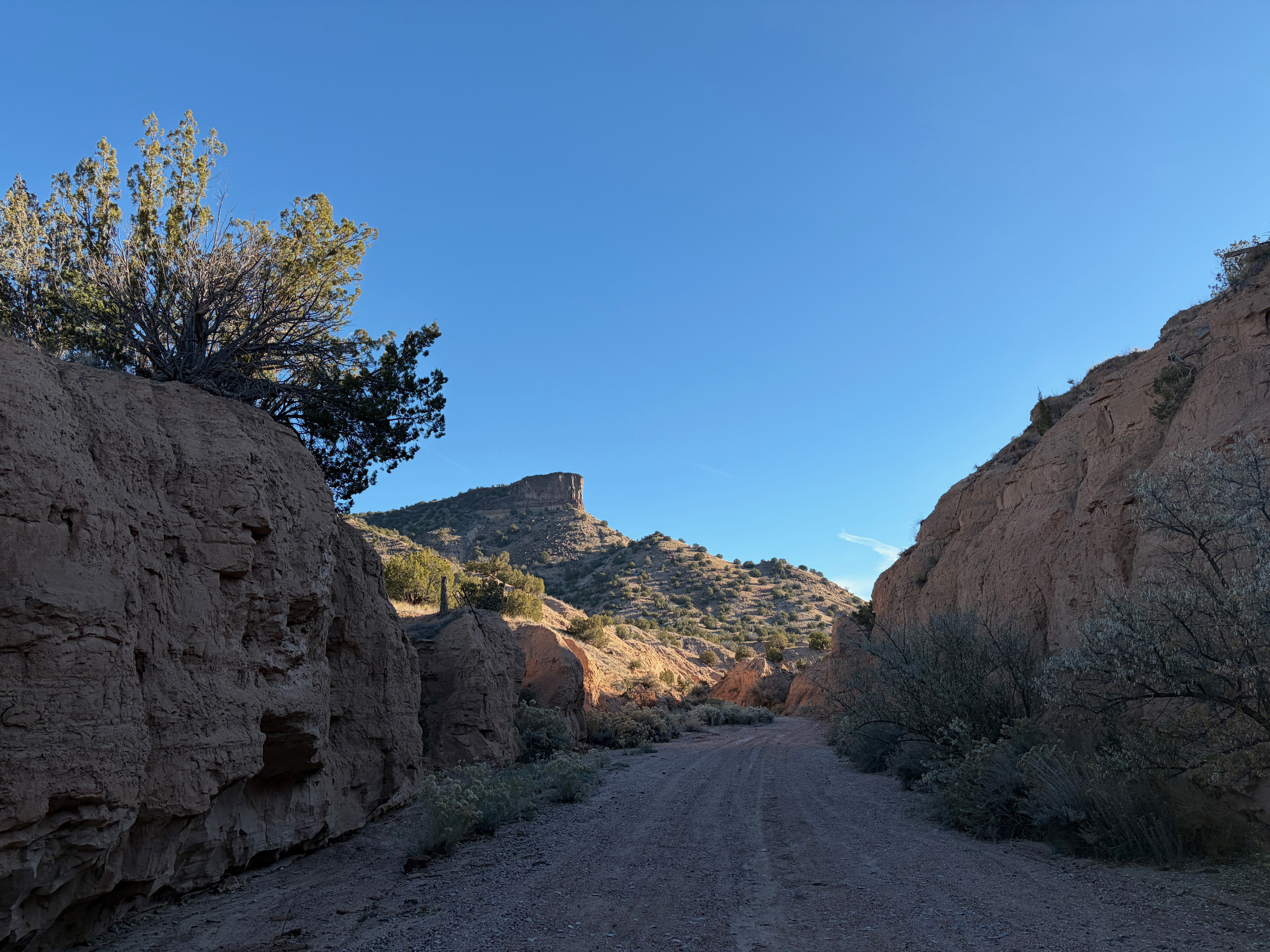
It was so-called Black Friday, a good time to avoid retail stores and to work off an excessive amount of mashed potatoes and the appropriately named stuffing from the day before. The drive leaves the Relief Route 599 at Camino la Tierra and wends its way through the tony neighborhoods of Las Campanas. At about 2 miles of this junior autopia, take a right on to Old Buckman Road. The road is good dirt from here.
This route is historic in the it was path of the Santa Fe spur of the Denver and Rio Grande Western Railroad (D&RGW). The was popularly called the Chili Line for the condiment that it was famous for transporting. Henry S. Buckman was a Oregon lumberman who purchased a lease to cut timber on the Parajito Plateau. It was Buckman that constructed the road up the west side of the Rio Grande to what would later become Los Alamos Ranch School for Boys that would be attended by a young Robert Oppenheimer.
Three miles down Old Buckman Road the route joins Cañada Ancha or “wide ditch” in Spanish. This takes us deeper into history to the Spanish Colonial period. We are now on the historic path of El Camino Real or The King’s Road. This is the segment that led generally north from Santa Fe to the Española Valley. This way passes several large groundwater pumping facilities to slake the relentless thirst of the Greater Santa Fe Area.
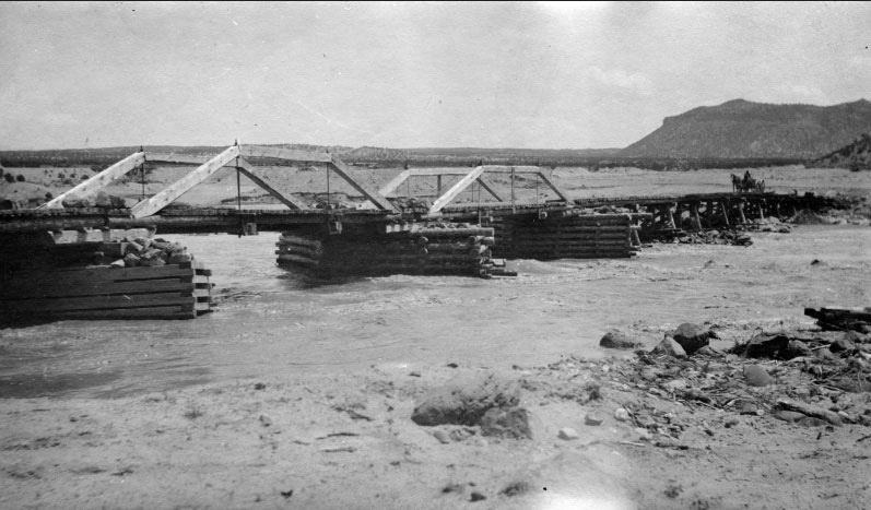
After passing the Diablo Canyon trailhead, Old Buckman Road terminates at the site of the town of Buckman. Henry Buckman constructed a crude bridge across the Rio Grande to haul his lumber down from Los Alamos and a small town sprang up on the site. This would be the only bridge in the area for many years until the Otowi Bridge was constructed on HIghway 502 to the north to handle the heavy traffic into Los Alamos.
Henry Buckman’s Bridge c.1915. That’s Otowi Peak in the distance. Photo courtesy of the Los Alamos Historical Society.The bridge was destroyed in the flood of 1921. Photo courtesy of the Los Alamos Historical Society.
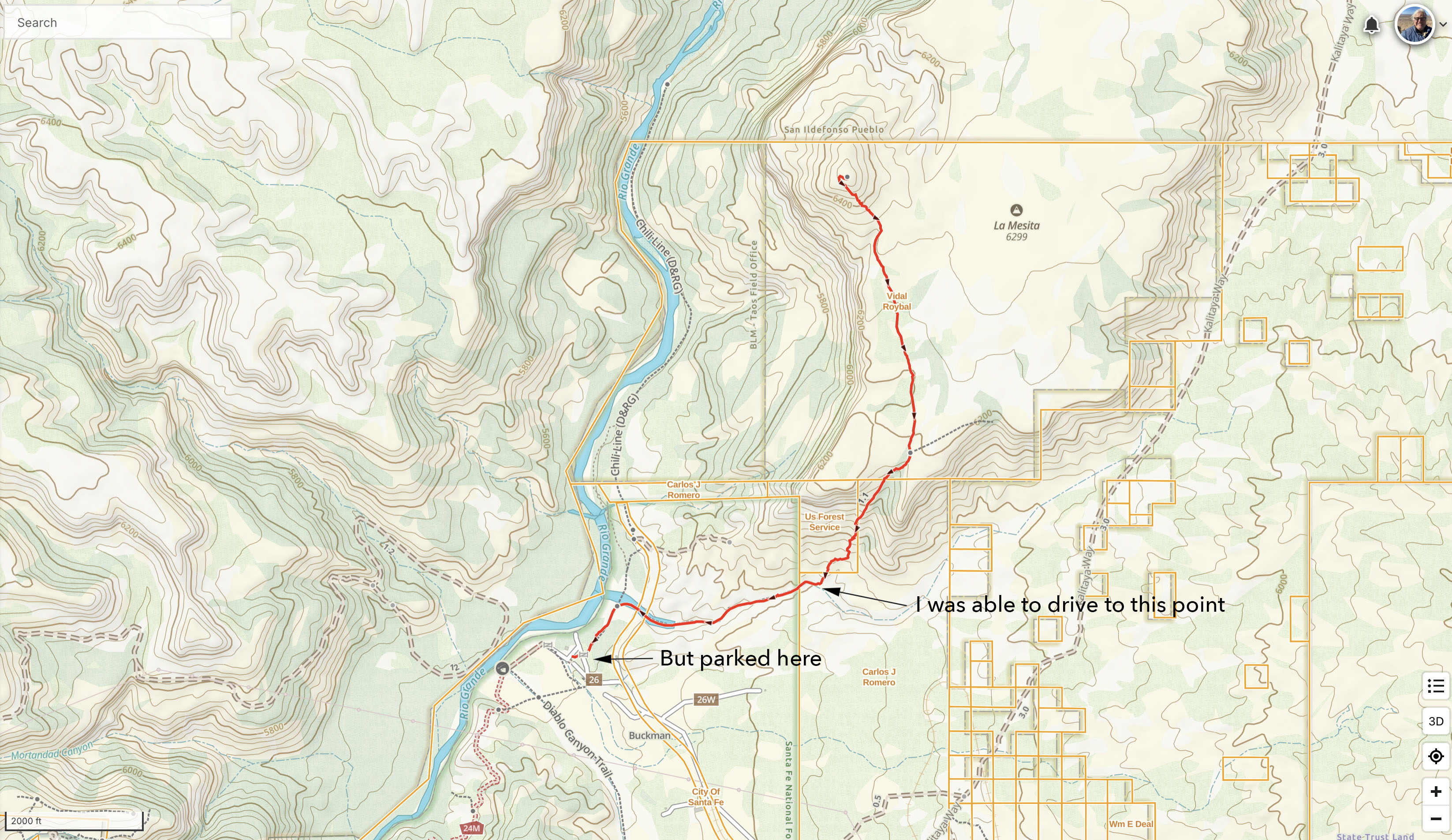
Although I was able to drive through a gate and up the wash past the site Old Buckman to the point at which the trail leaves the wash, I decided that it was better to park at the outhouse back in the Santa Fe National Forest. According to my property maps, the route crosses a corner of property of Carlos J. Romero at the start of the trail up the mesa’s apron.
Map showing private property. Click to enlarge
As I left Whitedog at the Buckman trailhead frost and ice glittered along the sandy road. I felt I was moving even further into the past. Before the tony neighborhoods and thirsty wells of Santa Fe, Before Henry Buckman and his rapacious appetite for ponderosa, even before The King’s road. Buckman Mesa reverts to La Mesita, reverts to Otowi Peak and the people of San Ildefonso Pueblo, and even to the people before them who made the cryptic rock art and petroglyphs on the rocks, to the rocks themselves of Rio Grande Rift and the Santa Fe group.
I drove seemingly back in time up this wash only to turn back to public land and walk in from the Rio Grande.
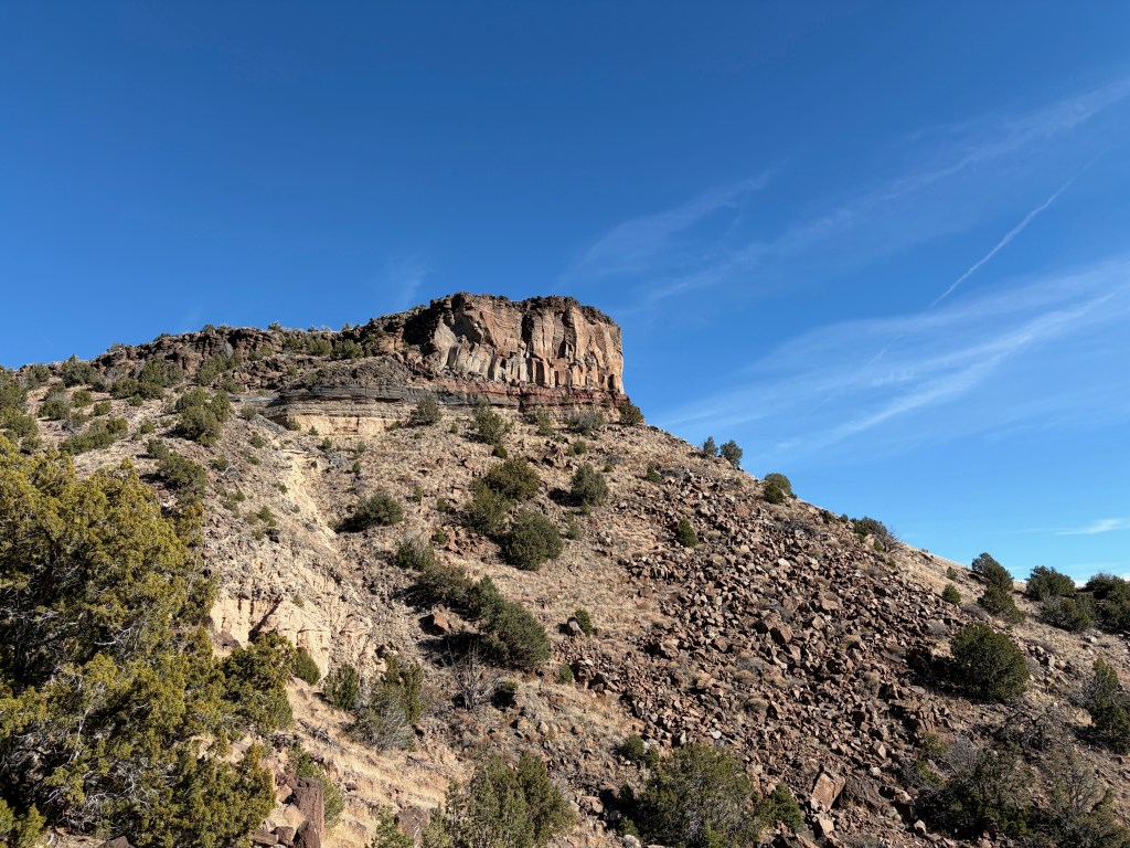
The igneous geology of this area is fascinating. What my foreign eye first took to be sedimentary layers of sandstone interspersed among the obvious lava basalt of the volcanos of the massive Jemez Lineament turns out to be pyroclastic duff – or the massive amount of volcanic ash spewed across this dramatic terrain by two massive explosions about 1 and 1.5 million years ago. This ash settled into the striations that mimic the water-washed layers sedimentary rock. These igneous layers are what we now see among the obvious lava on the way up this ancient trail.
The trail to the summit is very good. It seems to be well used and maintained and quite old given the various eroded threads.
Once on the summit I heard the calling of Sanhill Cranes. As I looked down into the Rio Grande Gorge I spotted a large phalanx of these birds flying south down the river. Several more groups of these wonderful birds followed. I later spoke to a couple that said these were stragglers migrating later than usual following waterways into Mexico for the winter.
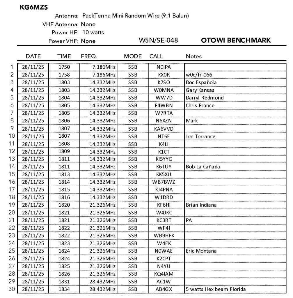
As Fred also mentions there are two large piles of basalt on the summit that are perfect for stringing an antenna across. Radio conditions were very good and I racked up 30 SSB contacts in about 45 minutes on 4 bands.
Click on any photo to enlarge
Looking south over La Mesita down to Buckman on the Rio Grande to the Caja del Rio Plateau and gorge. Ortiz and Montoso Peaks.The station with Clara Peak and Roman Peak in the background.Looking east to the Truchas Peak area across the Pojoaque Valley.The antennaLooking north past Black Mesa on the San Ildefonso Pueblo to Wheeler Peak and the Taos Plateau.Looking east to the dramatic Parajito PlateauNorthwest to Caballo, Chicoma and Clara
Sunrise at the new and improved traihead. Cerro Roman off to the left.
22 NOVEMBER 2025 W5N/SE-049
Two Stars – a nice summit. I’d do it again. Recommended.
Elevation:
7,707′
Route:
Cross country
Hike Distance:
2.8 miles round trip
Elevation Gain:
700′ (90′ on the return)
Navigation:
Moderate
Steepness:
Steep at the end
Vehicle:
Passenger car
Road:
Good dirt road
Cell Coverage:
Excellent Verizon
Hike basics
There had been rain and snow in the upper elevations during the week in North Central New Mexico. My Saturday schedule suddenly opened up and I was looking for a nearby summit that would be free from the expected mud and snow.
I’d driven up Forest Service Road 114 three times recently to activate summits on the roof of the Jemez Mountains and I knew that road was well graded and drained. I’d been scoping out the trailhead for Cerro Roman and suspected that there might be better to start a little lower than others have indicated on previous activations.
This route starts a few hundred yards down from the horseshoe bend that others have parked at. This route contours around the humps on the ridge and travels along relatively level terrain.
K1JD John wisely suggests good footwear for this one. For my 70 year old ankles this means my La Sportiva high top boots. This lower route avoids some of the steep and treacherous lava cobblestone footing that can send one flying into the abundant cacti. The last steep part is unavoidable, but by watching mt feet when I walked and firmly stopping to look ahead — a practice that is contrary to my normal way of hiking — I found that I could stay on my feet and not end up on my butt.
The terrain on this route is relatively open and it was easy to link up all the little meadows. There were none of the deadfall cul de sacs I found on Polvadera Peak that necessitated endless backtracking. I found the hiking here quite enjoyable.
The summit affords a nice view and some trees tall enough to support antennas. The activation zone is spread out between two small knolls and could provide space for an army of activators.
Radio condition were good on the upper bands. Got some nice DX into Europe with Aleksander in Slovenia and Chris in France. 40m was not working at all for me as Scott WA9STI couldn’t hear me on that band. I did manage to get Scott (as club call WA6LE) on 20m. Also notable was a 2 meter contact with Linda WB0JNS 85 miles or so into southern Colorado.
The station.I brought two poles so I figured I use them. The trees were tall enough to have sufficed.Cacti, lava cobblestones and dead wood mark this routeSandia Crest to the southView north past the edge of the Taos Plateau and the Rio Ojo CalienteLooking west to Chicoma Mountain and Clara PeakLooking east to Truchas Peaks and Santa Fe Baldy over the excellent FS Road 114


Leave a comment